Titan Images 2015

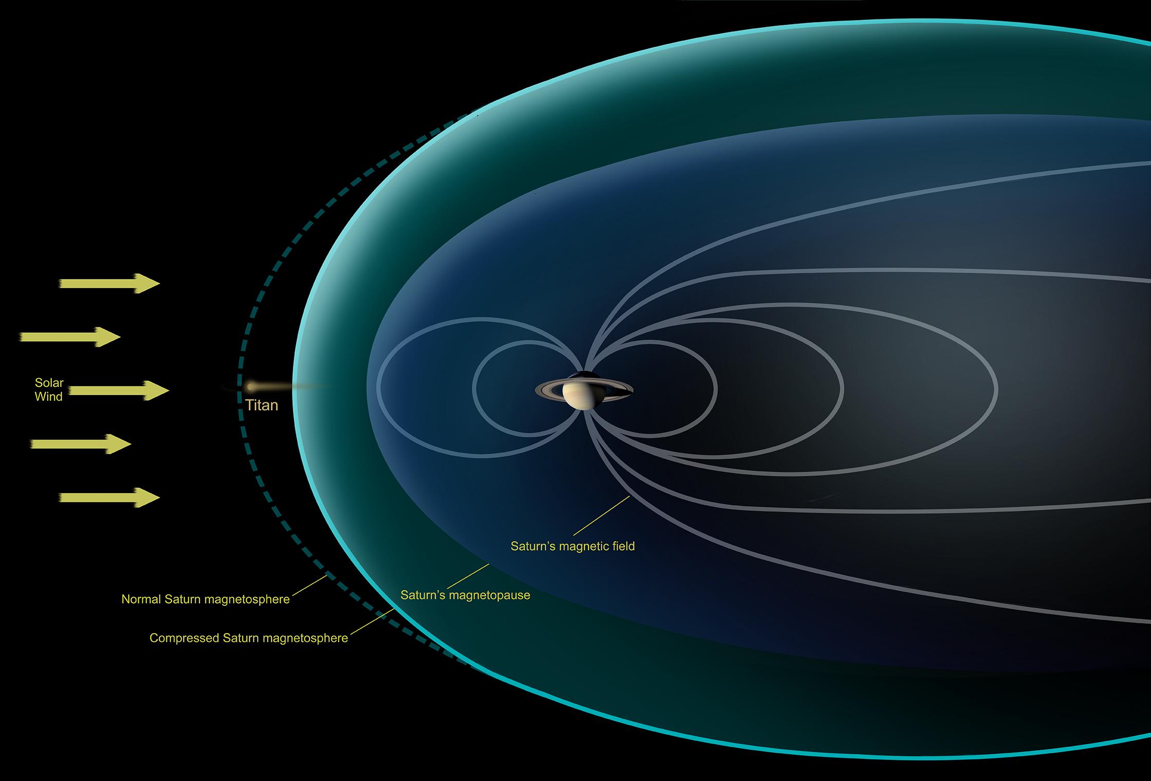
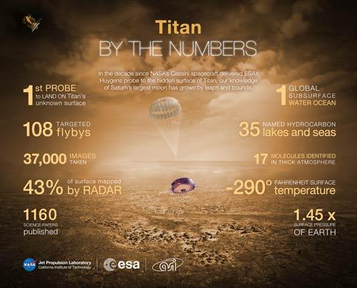
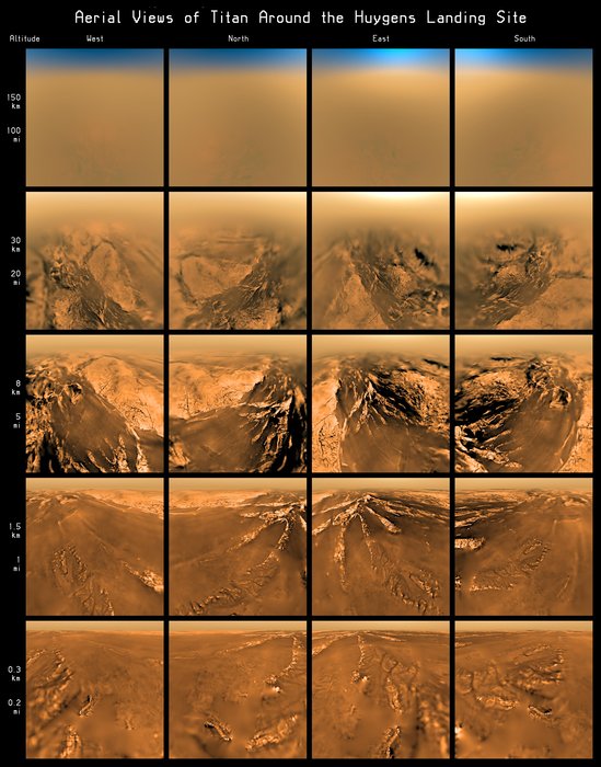
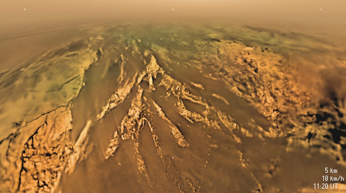
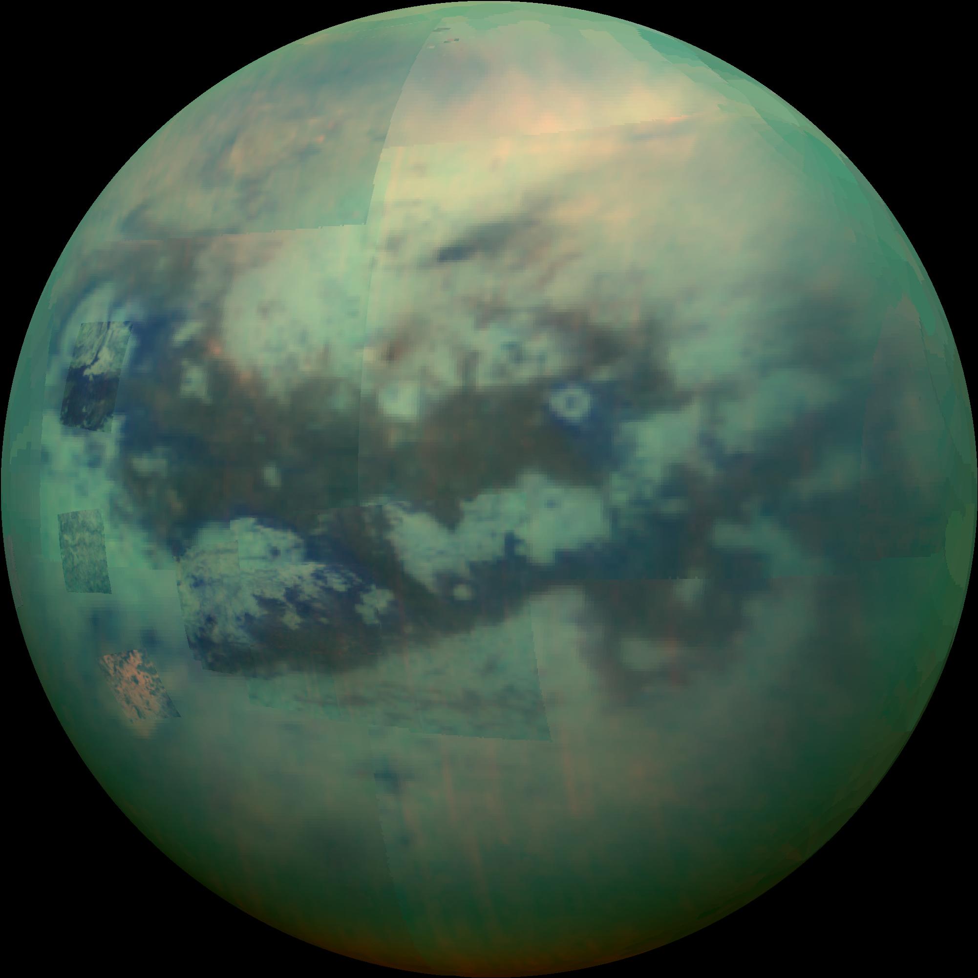
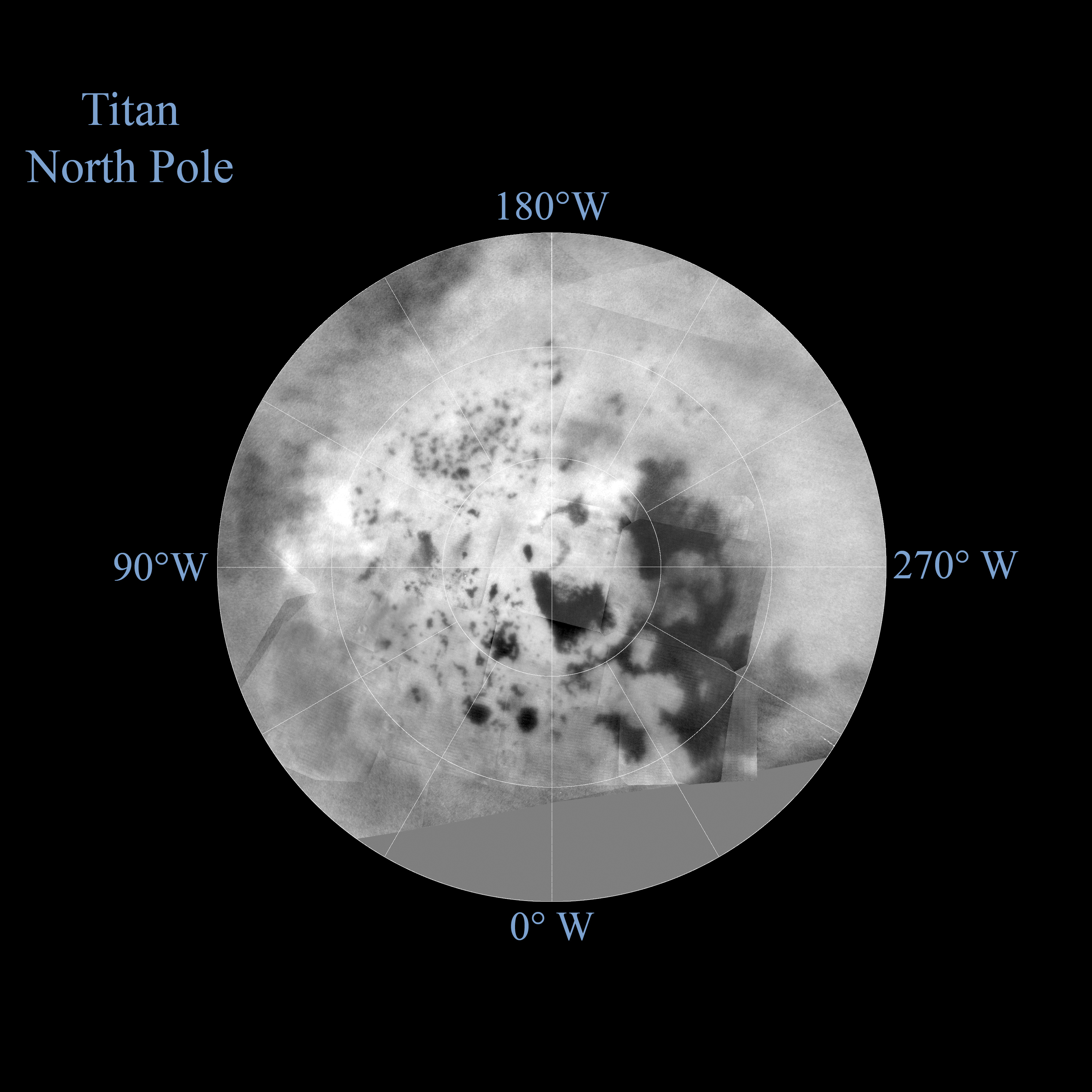
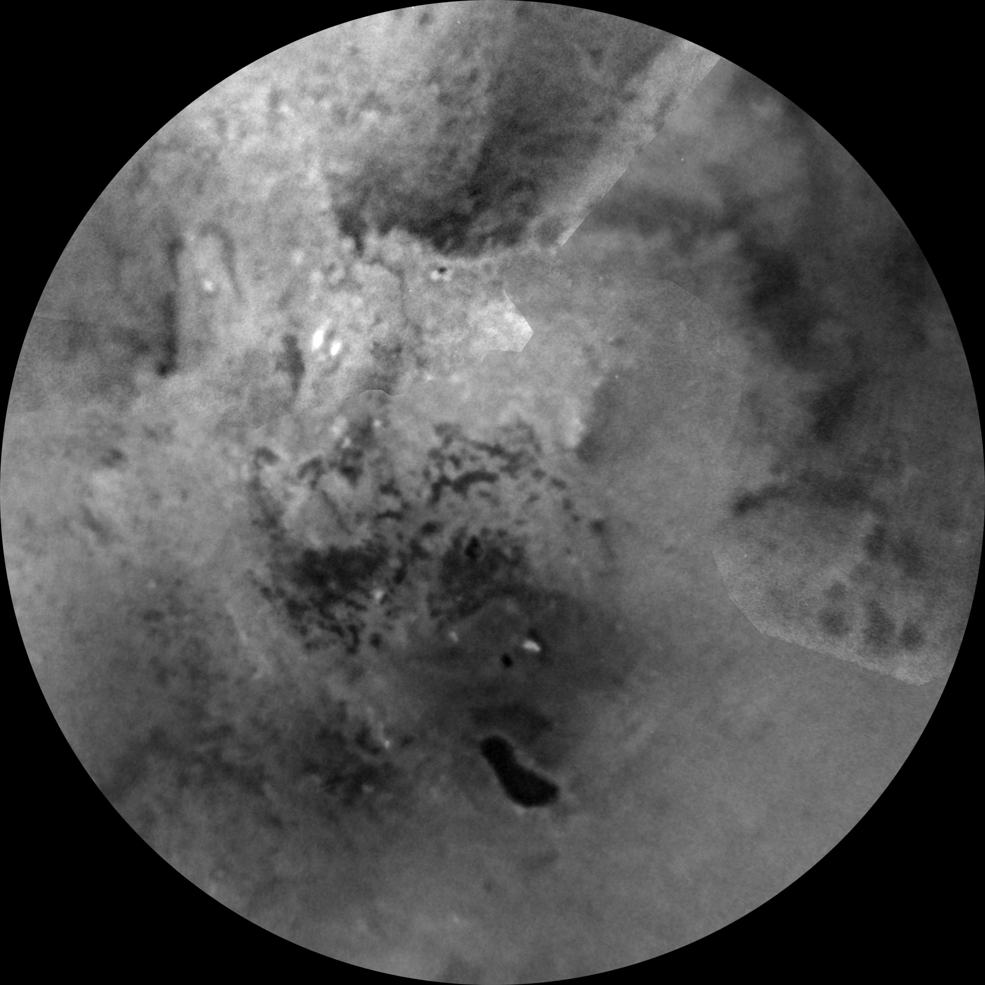
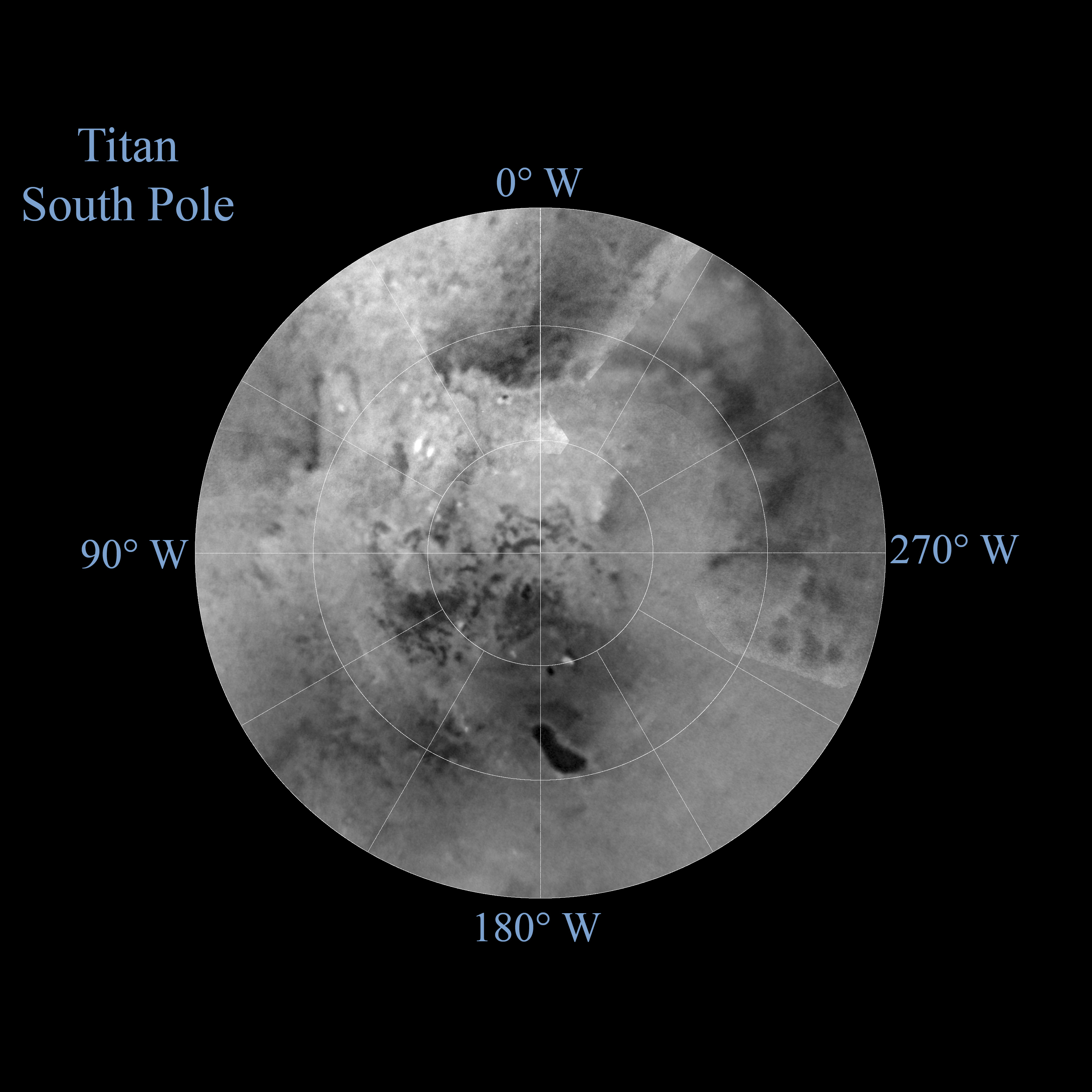
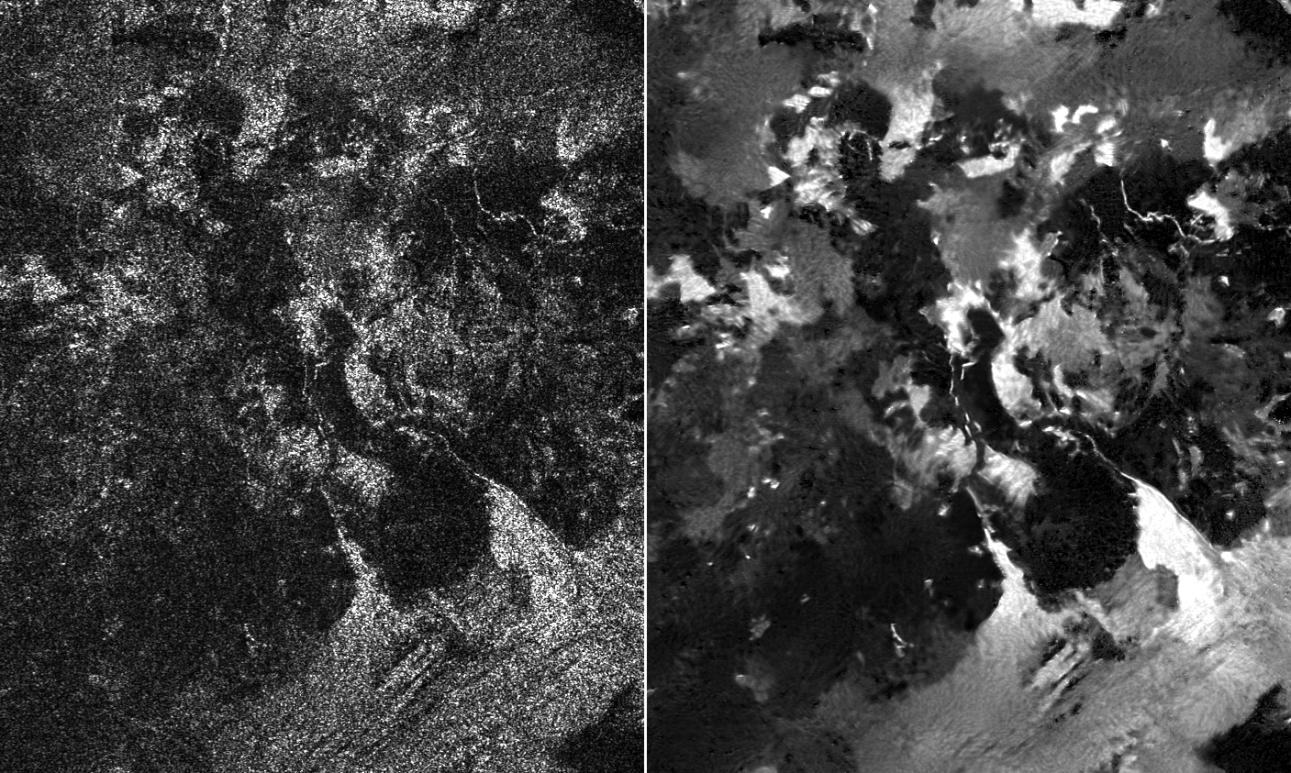
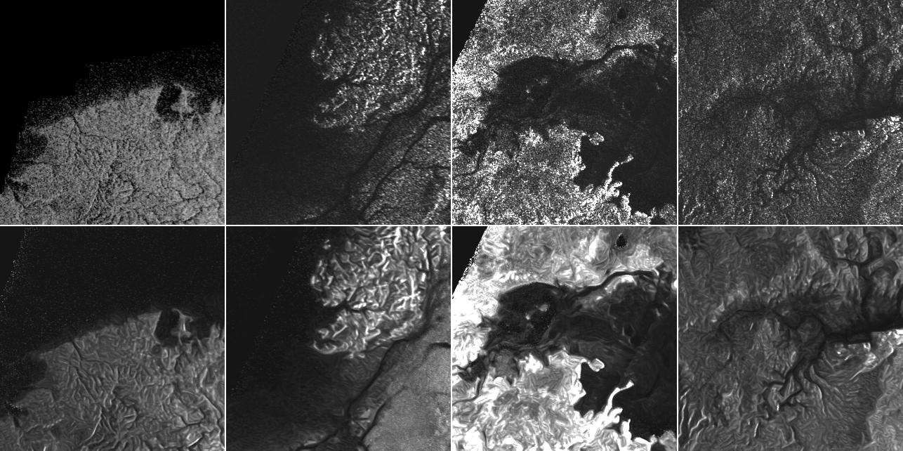
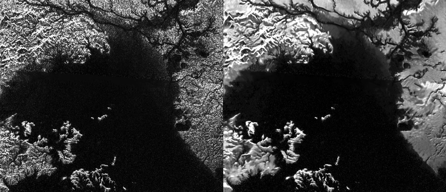
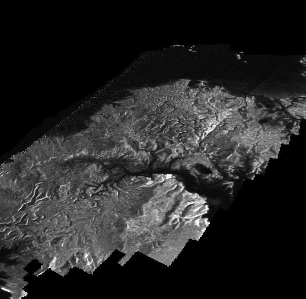
This global view of Saturn's largest moon Titan corresponds to a composite image of the Opaque Moon obtained in the infrared spectrum from the Visual and Infrared Mapping Spectrometer (VIMS) of the Cassini probe on November 13, 2015 during the "T-114" flyby. In this mosaic, blue corresponds to wavelengths centered at 1.3 microns, green represents wavelengths centered at 2 microns and red corresponds to wavelengths centered at 5 microns. Any image taken at visible wavelengths centered around 0.5 microns would only reveal the hazy and opaque atmosphere of the giant moon. The images acquired at near-infrared wavelengths from the Cassini spacecraft allow us to see through the haze or the atmosphere and to identify surface features.
During the T-114 flyby, the closest-approach altitude reached by the Cassini probe was particularly high compared to typical flybys. The closest-approach altitude attained by the Cassini probe was in fact 6,200 miles or 10,000 kilometers, largely higher than typical flybys which oscillate around 750 miles or 1,200 kilometers. The remarkably high flyby allowed researchers to collect moderate-resolution images over wide regions. The VIMS instrument typically obtained moderate resolutions around a few kilometers per pixel. The regions observed in this disk are mostly found on the Saturn-facing hemisphere of the Orange Moon.
One can see in particular the famous contrast between dark regions found at low latitudes and bright regions or regions with a relatively high albedo. One can notice the dark regions Fensal and Aztlan which are roughly parallel and which form a laid "H". Fensal is found to the north and Aztlan represents the segment to the south. Fensal and Aztlan are dominated by linear and parallel dunes extending over long distances. The dunes are reminiscent of the Seif Dunes found in the Namib Desert.
Some areas or subframes in the mosaic are revealed at higher resolution than elsewhere because they were taken near closest approach. As a result, they show more detail. However, they cover smaller portions than areas acquired when the Cassini probe was farther away from the Opaque Moon. The best VIMS image obtained so far of Menrva is revealed here. Menrva appears to be the largest confirmed impact crater present on Titan. Menrva can be identified in the upper left part of the dark Fensal near the limb at left, above center. Menrva had been clearly revealed in radar data obtained from the Radar Mapper of the Cassini probe in 2005. One can also notice the bright basin Hotei Regio to the left of the dark Aztlan. Eastern Xanadu can be seen as well in subframes with a similar resolution.
Due to seasonal changes, one can notice some changes in the appearance of the disk compared to VIMS data obtained during the T-9 flyby performed on December 26, 2005. Currently, the northern hemisphere is experiencing the late Spring season whereas the southern hemisphere is experiencing the late Autumn season. Therefore, since the VIMS observations of 2005, the Sun has migrated higher in the sky of Titan's northern hemisphere as Summer approaches and lower in the sky of Titan's southern hemisphere as Winter approaches. Changes in the illumination angle relative to the Titanian surface allow the northern latitudes to appear brighter and the high southern latitudes to appear darker.

Image Credit: NASA/JPL/University of Arizona/University of Idaho.


This view of Saturn's largest moon Titan reveals the dark areas known as Fensal and Aztlan which are interconnected and which form a H. Fensal which can be found in the north and Aztlan which can be found in the south appear at low latitudes on the Opaque Moon. They are dominated by Seif Dunes or by linear and parallel dunes extending over long distances and shaped by prevailing winds.
Titan unveils striking similarities with the Earth. For instance, the dense hazy atmosphere of the Orange Moon engenders transient, dynamic clouds as well as cyclones. Evaporation and condensation processes take shape and clouds can generate rain like on Earth. Lakes, seas and rivers can be found at high latitudes.
The meteorological cycle of Titan is relatively familiar but it doesn't involve water like on Earth. Titan is dominated by a meteorological cycle involving methane and ethane which can appear as a liquid on the ground in the harsh environment of the giant moon. Titan is in fact a really alien world with a solid surface made of water ice and dune fields composed of hydrocarbon sands. Researchers try to identify, via a regular monitoring of the surface from the instruments of the Cassini probe, surface changes as well as meteorological phenomena to better understand the dynamics of winds, the dynamics and the nature of dunes or surface features.
The view was obtained with the Narrow-Angle Camera of the Cassini probe on July 25, 2015 on the basis of a spectral filter sensitive to wavelengths of near-infrared light centered at 938 nanometers. The image was captured at a distance of about 450,000 miles or 730,000 kilometers from the Orange Moon and at a Sun-Titan-probe, or phase, angle of 32 degrees. The camera is orientated toward the leading side of the Opaque Moon and north is in the upper part of the disk.

Image Credit: NASA/JPL-Caltech/Space Science Institute.


This global digital map of the Opaque Moon Titan was generated on the basis of images acquired from the Imaging Science Subsystem (ISS) of the Cassini probe. The map was created in June 2015 using data captured through the Titan flyby on April 7, 2014 called T100. The views were obtained using a spectral filter centered at 938 nanometers, enabling scientists to identify variations in albedo or reflectivity across the surface of the Orange Moon. The different portions don't show any topographic shading due to the scattering of light by the dense atmosphere of this remarkable moon.
The map corresponds to an equidistant projection and has a scale of 2.5 miles or 4 kilometers per pixel. The actual resolution is far from being uniform and is quite heterogeneous across the map. The best coverage turns out to be close to the map scale along the equator near the center of the map at 180 degrees west longitude whereas the lowest resolution coverage appears in the northern mid-latitudes on the sub-Saturn hemisphere.
The resolution in the northern polar region has significantly improved since the previous version of the same type of map in 2011. The methane lakes or seas present in the high latitudes of the northern hemisphere can now be clearly seen in the mosaic. The end of the Winter season and the development of the Spring season in the northern hemisphere have been accompanied by a significant increase in solar illumination of the north polar region which is now clearly visible in the near-infrared spectrum. Thus, thanks to seasonal changes, the cameras of the Cassini probe have been in a position to obtain images of the enigmatic land of lakes and seas in the high latitudes of the northern hemisphere.
This map represents an update to the previous versions published in April 2011 and February 2009. Data obtained during the past four years has fully filled in missing data in the north polar area. The resolution of the Xanadu area is now better. The most recent data appearing in the map were taken in April 2014. There remains a data gap representing approximately 3 to 5 percent of the Titanian surface. This data gap can be found in the northern mid-latitudes on the sub-Saturn hemisphere of the Opaque Moon. The missing data in the map appearing in the northern hemisphere are covered by a grey uniform color. The Cassini probe is expected to capture the missing data during the Titan flybys on December 15, 2016 and March 5, 2017.
The projection of this map was generated on the basis of a mean radius of 1,600 miles or 2,575 kilometers for Titan. The Orange Moon is considered perfectly spherical until a model of its shape based on several views tied together at defined points on the ground is produced in the near-future. The map clearly shows the contrast between the dark low-latitude areas and the bright areas which dominate the moon. The contrast between the dark lakes or seas and their bright surrounding is also striking.

Image Credit: NASA/JPL-Caltech/Space Science Institute.


The maps above represent the polar regions of Titan where lakes or seas can be clearly identified. The views correspond to polar stereographic maps produced in 2015 on the basis of the best available images of Saturn's largest moon obtained from the Cassini probe. The views of the southern hemisphere and the northern hemisphere were captured by the imaging cameras of the Cassini spacecraft using a spectral filter centered at 938 nanometers. In the near-infrared spectrum, scientists can see through the haze and unveil the landscape or the topography of the giant moon via variations in albedo across the surface. These maps incorporate imaging data taken through the Cassini's flyby of Titan on April 7, 2014 known as T100.
Our view of the north polar region of Titan has significantly improved thanks to the development of the Spring season in the northern hemisphere. When the Cassini probe entered into the Saturn System in mid-2004, the north polar region of Titan was poorly illuminated due to the Winter season in the northern hemisphere. The seasonal changes have allowed the north polar region of the Opaque Moon to be better illuminated. The new map of the north polar region unveils much more detail than the previous version of the north polar map and it fills in a large region of missing data. Researchers can combine the Synthetic Aperture Radar (SAR) mapping of the north pole of the Orange Moon and the near-infrared data of these maps to better understand the topography or the landscape.
The confrontation of the two polar maps clearly shows that there is a much higher concentration of lakes or seas in the high latitudes of the northern hemisphere. The lakes or seas are likely of composed of methane and ethane. One can notice the three big lakes or seas found in the high latitudes of Titan's northern hemisphere. Kraken Mare which is the largest body of surface liquids on Titan corresponds to the lower-right dark patch of the disk. Kraken Mare is approximately the size of the well-known Caspian Sea on our planet with a surface area of about 150,000 square miles or 400,000 square kilometers. The second largest body of surface liquids Ligeia Mare can be noticed just above Kraken Mare. The surface area of Ligeia Mare is about 49,000 square miles or 126,000 square kilometers. Close to the north pole of Titan, one can notice Punga Mare which is approximately 240 miles or 380 kilometers across.
The lower portion of the disk in the north polar map appears uniformly gray because there is a gap in the imaging coverage of this area to date. This area may be filled in when the Cassini probe scans the area during the flybys on December 15, 2016 and on March 5, 2017. The south polar region of Titan clearly shows a lower concentration of liquids on the surface. One can notice in the south polar map Ontario Lacus, a dark, footprint-shaped feature or kidney-shaped feature located at 180 degrees west. Ontario Lacus which was the first lake or sea identified on Titan is by far the largest body of surface liquids in the southern hemisphere. A smaller pool of liquids can be identified just above Ontario Lacus. This lake which appears as a very dark spot in the south polar map is known as Crveno Lacus. Another major feature found in the southern hemisphere is Mezzoramia, a dark-albedo region located at the top of the southern hemisphere map or at 0 degree west.
One will notice that each map is centered on one of the poles. Grid lines show latitude in 10-degree units and longitude in 30-degree units. Therefore, one can notice that surface coverage extends southward to 60 degrees latitude. Regarding the full-size versions of these maps, the scale is 4,600 feet or 1,400 meters per pixel. The maps were produced on the basis of a mean radius of 1,600 miles or 2,575 kilometers for the Titanian sphere.

Image Credit: NASA/JPL-Caltech/Space Science Institute.


This image reveals two of Saturn's numerous moons as well as a portion of Saturn's rings. The bright patch in the upper part of the view corresponds to the tiny moon Pandora whose diameter is 50 miles or 81 kilometers. The giant moon Titan can be well discerned with its opaque and relatively uniform atmosphere in the middle of the view. One may believe at first glance that the small moon Pandora is farther from the camera than the giant hazy moon Titan whose diameter is 3,200 miles or 5,150 kilometers but that's an illusion. In fact, Titan is almost three times farther away. One will notice that the bright Pandora has an irregular shape whereas Titan is almost a perfect sphere.
The view was obtained from the ISS Narrow-Angle Camera of the Cassini spacecraft in visible green light on July 4, 2015. The image was taken at a distance of about 1.2 million miles or 1.9 million kilometers from the Orange Moon Titan and at a distance of 436,000 miles or 698,000 kilometers from Pandora. That's why the relative size of Pandora can be well overestimated in this view at first sight. North on Titan appears in the upper part of the disk and is rotated 19 degrees to the right.

Image Credit: NASA/JPL-Caltech/Space Science Institute.


A remarkable viewing angle is shown in the image revealing the Gas Giant Saturn in the background and its largest moon Titan in the foreground cutting the ring plane of the second largest Gas Giant in the Solar System. Saturn and Titan are both covered by a dense atmosphere and their appearance can show remarkable similarities.
However, the internal structure and the composition of Saturn and Titan are radically different. Saturn is in fact a gas ball devoid of any solid surface. The atmosphere of Saturn is mostly composed of hydrogen and helium. Other compounds such as methane, ammonia and ammonium hydrosulfide are also present in this exotic atmosphere and clouds of water can be encountered as well.
A remarkable atmosphere covers Titan. The Orange Moon shows a complex landscape and topography as well as a complex atmosphere made of a photochemical haze and several layers. The Titanian atmosphere which appears completely opaque from the camera of the Cassini probe is dominated by nitrogen and methane. Occasional methane clouds can take shape in the low latitudes and cyclones or systems of dynamic clouds can appear in the high latitudes or the polar regions of the Opaque Moon Titan.
The view was obtained in visible green light with the ISS Wide-Angle Camera of the Cassini probe on May 22, 2015. The camera was orientated toward the Ringed Planet Saturn from the unilluminated side of the rings, 0.3 degrees beneath the ring plane. The image was acquired at a distance of about 1.4 million miles or 2.2 million kilometers from the Gas Giant Saturn.

Image Credit: NASA/JPL-Caltech/Space Science Institute.


The image above reveals the disk of the Gas Giant Saturn and its largest moon Titan in the same field of view. Titan appears to be the second largest moon in the Solar System with a diameter of 3200 miles or 5150 kilometers. Titan is bigger than the planet Mercury and the Dwarf Planet Pluto. Ganymede which is Jupiter's largest moon is a little larger. One can clearly notice in this view that the Opaque Moon Titan is dwarfed by its parent planet Saturn. Saturn is the second largest planet in the Solar System with a diameter almost 23 times larger than that of Titan.
The relative size of Titan compared to the size of Saturn is remarkably small if we draw a parallel with the relative size of our moon compared to the Earth. The diameter of our planet is only 2.3 times the diameter of our moon. The relative size of Pluto compared to its largest moon Charon is even smaller since Pluto's diameter is just under two times the diameter of its grey moon Charon. Moons and planets can undergo strong tidal forces from the planets or moons moving in their neighborhood.
The image was obtained with the Wide-Angle Camera of the Cassini probe on April 18, 2015 using a spectral filter sensitive to wavelengths of near-infrared light centered at 752 nanometers. The camera is orientated toward the anti-Saturn hemisphere of the Orange Moon and north on Titan appears in the upper part of the disk. The image was taken at a distance of about 930,000 miles or 1.5 million kilometers from Saturn's largest moon.

Image Credit: NASA/JPL-Caltech/Space Science Institute.


The image above obtained in visible light from the Narrow-Angle Camera of the Cassini probe on March 25, 2015 shows the crescent of three moons of the Gas Giant Saturn. Titan appearing in the right part of the view is by far the largest moon of Saturn with a diameter of about 3,200 miles or 5,150 kilometers. Titan was captured at a distance of about 1.2 million miles or 2 million kilometers from the camera. Mimas found in the lower part of the view was captured at a distance of 1.9 million miles or 3.1 million kilometers from the camera. The diameter of Mimas is 246 miles or 396 kilometers. Rhea found in the upper left part of the image was captured at a distance of approximately 2.2 million miles or 3.5 million kilometers from the camera. The diameter of Rhea is 949 miles or 1,527 kilometers. In this view, the camera was orientated toward the anti-Saturn hemisphere of the Opaque Moon. North on Titan appears in its upper part.
One can notice in particular the marked contrast between the appearance of Titan's crescent and the appearance of the crescent of Mimas and Rhea. This contrast is related to the presence of a significant atmosphere on Titan and to the absence of atmosphere on the two icy moons Mimas and Rhea. The crescent of Titan appears bright and uniform due to its dense et opaque atmosphere which is relatively uniform. The crescent appears fuzzy due to the gas layers and the upper atmosphere. The Titanian atmosphere tends to refract solar radiations around the moon so that the crescent goes a little further around the moon than it would on an airless planet or moon like Mimas or Rhea. The crescent of the icy moons Mimas and Rhea appears irregular or rough due to the absence of atmosphere and to the presence of a significant amount of impact craters. Thanks to its atmosphere, Titan has a strongly eroded surface and erosion tends to erase impact craters over time like on our own planet.

Image Credit: NASA/JPL-Caltech/Space Science Institute.


This view of Titan's disk clearly shows landscape features hidden beneath the opaque atmosphere. One can notice the contrast between dark and bright areas, in particular at low latitudes. The dark region of Senkyo, named after a Japanese paradise, can be seen in the lower portion of the disk, below a bright, roughly circular area. A portion of the network of seas, lakes or rivers found in the north polar region can also be clearly observed in this view. The gas layer of the atmosphere or the haze can be clearly identified above the north polar region. Water in the harsh environment of Titan appears in its solid form and can be as strong as rock.
The image was obtained with the Narrow-Angle Camera of the Cassini probe on January 8, 2015 using a near-infrared filter sensitive to wavelengths of 938 nanometers. The camera was orientated toward the Saturn-facing side of the Orange Moon. North is in the upper part of the disk and inclined 33 degrees to the right. The photo was taken at a distance of about 1.2 million miles or 1.9 million kilometers from Saturn's largest moon.

Image Credit: NASA/JPL-Caltech/Space Science Institute.


The mosaic above showing a landscape portion of Saturn's largest moon Titan is made of Synthetic Aperture Radar (SAR) images acquired from the Radar Mapper of the Cassini spacecraft. The region shown here is known as Leilah Fluctus. Leilah Fluctus can be found at 55 degrees north latitude and 80 degrees west longitude. North appears toward right in each radar view. The area represented in each radar image is approximately 50 miles or 80 kilometers wide.
The view in the left part of the mosaic corresponds to a traditional radar image in which a strong noise can be discerned. The image in the right part of the mosaic corresponds to the same view without the noise thanks to a new technique known as the despeckling technique which erases the electronic noise and makes the brightness variations in the radar image more progressive or uniform. Therefore, it becomes easier for researchers to analyze or interpret landscape features such as mountains, plateaus, dunes, seas, rivers or lakes.
The topography of the image in the right part of the mosaic appears clearly clearer and the famous bright cone-shaped features of Leilah Fluctus, located in the lower part of the view, can be well identified. Are those bright features related to a cryovolcanic event or to a meteoritic impact ? The shape of the cone-like features is reminiscent of alluvial phenomena taking shape on our planet. The cone-like features may be composed of water ice and may have been generated by the action of floods or rivers. The contrast between dark and bright features in the area is remarkable suggesting the potential presence of radically different materials.

Image Credit: NASA/JPL-Caltech/ASI.


The mosaic of radar images above shows Synthetic Aperture Radar (SAR) images of Titan's landscape in the high latitudes of the northern hemisphere where most of the lakes or seas are found. The radar data were captured with the Radar Mapper of the Cassini probe. The images in the upper part of the mosaic were generated with the traditional way used since the beginning of the Cassini mission in the Saturn System a decade ago. The images in the lower part of the mosaic correspond to the same views which have been processed by using a new technique, called the despeckling technique, to handle or remove the noise.
Thus, the brightness variations in the topography or landscape are more progressive or uniform and researchers can interpret or analyze more easily landscape features such as mountains, hills, plateaus or channels. The three view pairs from the left unveil, in particular, bays and spits of land in the major lake or sea Ligeia Mare. The views in the rightmost column reveal a valley network along Jingpo Lacus, one of the larger lakes in the north polar region of the Orange Moon. The lakes, seas and rivers are likely composed of a mixture of methane and ethane. The north can be found toward the left in these views and each landscape portion of the mosaic is about 70 miles or 112 kilometers wide.

Image Credit: NASA/JPL-Caltech/ASI.


The mosaic above shows radar views of the area of Ligeia Mare, one of the major bodies of liquids found in the north polar region of Saturn's largest moon Titan. The view in the left part of the mosaic corresponds to a traditional Synthetic Aperture Radar (SAR) image or swath which was obtained with the Radar Mapper of the Cassini probe. The view in the right part of the mosaic corresponds to the same image or swath without the electronic noise. This clearer view of the topography was produced by using the despeckling technique which allows us to eliminate the granulation or the noise in the radar views. Thus, the landscape becomes easier to interpret or analyze because brightness variations are more progressive or uniform. The despeckling process clearly increases or improves the visibility of channels flowing down to the lake or sea. The seas, lakes or drainage channels are likely composed of a mixture of methane and ethane. Familiar precipitation, evaporation and condensation processes may occur in the area.

Image Credit: NASA/JPL-Caltech/ASI.


This image corresponds to a processed Synthetic Aperture Radar (SAR) view of Titan's landscape obtained from the Radar Mapper of the Cassini probe during a flyby on April 10, 2007. The perspective view was generated on the basis of a traditional radar image by using a new technique called despeckling which allows researchers to handle noise and to obtain clearer images which are easier to interpret or analyze. Thus, scientists are in a position to generate altimetry data, 3-D views or digital elevation maps.
The perspective image was produced on the basis of a technique named radargrammetry which enables us to determine the height or the altitude of surface features. The landscape shown here is found near the eastern shoreline of Kraken Mare, the largest pool of liquids found in the north polar region of the Opaque Moon. The dark and uniform areas represent the liquids which are probably mainly composed of methane and ethane. The resolution here is about half a mile or 1 kilometer and the altimetry data show that the region is smooth overall since there is a maximum amplitude of 0.75 mile or 1.2 kilometers in height. One can also notice that the identified channels flow downhill.
Just above the lower left part of the image, one can notice an area of bright slopes. Such topographic ruptures are known as knickpoints. A knickpoint represents a place on a river where a sharp change in slope takes shape. The knickpoint can reveal a fall or a torrent. The knickpoint may result from stratification in the bedrock or erosional processes at work. The knickpoint may also be explained by an unusual way the surface reacts to runoff events such as floods following significant storms.

Image Credit: NASA/JPL-Caltech/ASI.


The image in the upper part of the table corresponds to a diagram which shows the action of the solar wind against the magnetic field of the Gas Giant Saturn. This configuration of the magnetic field is based on data gathered from NASA's Cassini probe during a flyby in December 2013. At that time, the magnetic field appeared to be highly compressed so that the Opaque Moon Titan was evolving outside the magnetic field. Normally, Titan is inside the magnetic field of Saturn close to the boundary of the magnetic field. The dashed curve indicates the normal limit of the magnetic field. The view in the lower part of the table shows the same diagram with annotations.
In this particular flyby of December 2013, Titan was not protected from Saturn's magnetic field and was fully exposed to the solar wind. The researchers with Cassini's magnetometer team noticed that the Orange Moon showed some similarities to Mars, Venus and comets in its behavior or interactions against the solar wind. In fact, those planets as well as comets don't show any apparent internal magnetic field. A magnetic field may represent a shield against the action of the solar wind which is likely to blow away an atmosphere. The researchers observed that the solar wind draped itself around Saturn's largest moon, generating a shockwave that took shape around Titan where the full-force solar wind smashed into the opaque atmosphere. Prior to this observation, scientists had believed that the Orange Moon would have a different kind of interaction with the solar wind due to the complex chemistry of Titan's atmosphere.

Image Credit: NASA/JPL-Caltech.


The illustration above shows an artist's representation of the Huygens probe with its parachute during the atmospheric plunge toward Titan's surface as well as key figures upon the exploration of the Opaque Moon. The Huygens probe landed on the surface of Titan on January 14, 2005. In particular, numerous lakes, seas and rivers have been clearly identified from the Radar Mapper of the Cassini probe in the polar areas or in the high latitudes of Saturn's largest moon.

Image Credit: NASA/JPL-Caltech.


The images above show aerial views of Titan's surface obtained during the plunge of the Huygens probe on January 14, 2005. The historic touchdown occured at 13:34 CET or 12:34 GMT. The Cassini/Huygens spacecraft had performed a seven-year journey to reach the Saturn System. The Huygens module was released from the Cassini spacecraft, on December 25 2004, for a 21-day plunge toward the surface of the Opaque Moon Titan. The Huygens probe performed a soft landing after an unprecedented atmospheric descent which lasted 2 hours and 27 minutes. The module continued to send data from the surface to our planet, mainly via the Cassini orbiter, for another 72 minutes before the batteries were depleted.

Image Credit: ESA/NASA/JPL/University of Arizona.


Ten years ago, on January 14, 2005, the Huygens probe landed on Saturn's largest moon Titan. The images shown in this table unveil the installation of the Huygens probe into the Cassini spacecraft in the Payload Hazardous Servicing Facility at the Kennedy Space Center in July 1997. The Cassini-Huygens spacecraft entered the Saturn System in mid-2004 and the Cassini probe is still functioning and working today.

Image Credit: NASA/JPL-Caltech.


Titan Images 2014
Titan Images 2013
Titan Images 2012

Titan Images 2011
Titan Images 2010
Titan Images 2009
Titan Images 2008
Titan Images 2007
Titan Images 2006
Titan Images 2005, 2004

Back to main page