June 21, 2024: A Significant Role Of Waves In The Shape Of The Coasts In The Lakes Or Seas Of Titan ?
A new research work entitled "Signatures of wave erosion in Titan's coasts", published in Science Advances on June 19, 2024 and proposed by a team involving Taylor Perron and Rose Palermo reveals the potential influence of waves in the erosion and in the shape of the coasts of the lakes or seas on Saturn's largest moon Titan. Titan is the only extraterrestrial world known to harbor stable pools of liquid in the Solar System. Lakes and seas have been confirmed on the Opaque Moon as soon as 2007 thanks to images acquired from the Cassini orbiter. The first stable pool of liquids was identified in the high latitudes of the southern hemisphere. That pool is known as Ontario Lacus. Later, we found a region of lakes and seas in the high latitudes of the northern hemisphere. Kraken Mare, Ligeia Mare and Punga Mare are the major pools of liquids found in the northern hemisphere. The lakes, seas and rivers of Titan are thought to be composed of a mixture of methane and ethane. The composition of the lakes or seas must be influenced by seasonal factors and regional factors. The dynamics of the lakes, seas and rivers in that harsh environment is a major topic of research.
Thanks to the huge amount of data captured with the eyes of the Cassini orbiter in particular, we have been in a position to evaluate the potential dynamics of the lakes or seas of Titan. Most planetologists advance that the lakes or seas of Titan may be particularly flat or smooth on the basis of radar data in particular. Some researchers have advanced that some lakes or seas of that intriguing world may be almost as smooth as a mirror. Does it mean that there is a thin layer of viscous hydrocarbons above the liquid ? Are our interpretations of the radar signals in line with reality ? The new study proposed by MIT geologists suggests that the coasts of the major seas of Titan may have been shaped by waves. In other words, waves must have played a significant role in the erosional process of the coasts of the lakes or seas. That conclusion was made possible thanks to simulations that are in line with what we had suspected on the basis of remote images that suggest indirect and conflicting signs of wave activity. The first step in the research work was to model the ways in which a lake can erode on our planet. The model regarding the lakes of the Earth was then applied to the major pools of Titan in order to determine what type of erosion could have generated the shorelines observed in the Cassini views.
The models proposed by the group of researchers suggest that the shape of the coasts is closely linked to the action of waves. Astronomers will have to confirm that hypothesis with direct observations of the presumed waves. The Huygens probe had revealed, during its atmospheric descent on January 14, 2005, a complex landscape with a sharp contrast between bright hills containing a network of dark channels and a dark or brown plain that may represent an ancient lake or sea. The landing site was relatively close to the Equator in the southern hemisphere and it turns out, thanks to Cassini images, that the low or middle latitudes of Titan appear relatively dry compared to the high latitudes where the lakes, seas or rivers can be found. One can imagine the exotic interactions between the liquid dominated by methane or ethane and the coasts probably rich in water ice, hydrocarbons or organics. The mean density of the liquid in those seas or lakes is likely lower than that of liquid water in the oceans, seas or lakes of the Earth. The gravity of Titan at sea level is about 7 times lower than that of the Earth at sea level. In parallel, the mean atmospheric pressure at sea level on Titan is higher than that of the Earth at sea level. Therefore, the dynamics of the waves on Titan must be particular.
Like on Earth, the meteorology can significantly change from time to time and storms or heavy rainfall events can take shape. That can be the case in the low or middle latitudes during the long Titanian year in particular seasons. The infrared or near-infrared views acquired from the Cassini probe had clearly shown the development of dynamic clouds in the low or middle latitudes in 2010 for instance. That was the start of the Spring season in the northern hemisphere and the start of the Autumn season in the southern hemisphere. In the high latitudes of the southern hemisphere or in the high latitudes of the northern hemisphere, the meteorology can significantly influence the shape, the size and the dynamics of the lakes or seas. A quiet sea can become an active sea if the meteorology evolves implying strong winds that can engender strong waves as well. Planetologists or geologists must try to determine the exact composition of the crust, the exact composition of the coast and the exact composition of the lakes or seas in order to evaluate the potential action of waves on the erosion of the coast. The analytical work is clearly complex due to the limited amount of clues or information we have.
At first sight, one could imagine relatively strong waves in a sea like Kraken Mare due to the particularly low gravity and due to the relatively low density of hydrocarbons like methane or ethane. But one has to keep in mind that the mean density of the air at sea level on Titan is much higher than that of the air at sea level on Earth. If complex hydrocarbons or organics take shape in the upper part of the liquid due to interactions with the atmosphere or due to the fall of a type of snow rich in organics or hydrocarbons, a thin layer can take shape and prevent the development of waves. The radar signature of the lakes or seas on Titan may be explained by the presence of a thin layer that makes the pools flat or smooth. Is the radar interpretation correct ? We know that winds can be relatively strong on Titan. In the relatively dark areas of the low or middle latitudes of that world, linear and parallel dunes extending over long distances can be clearly observed on the basis of the radar images obtained from the Cassini orbiter. The shape of those dunes which look like the Seif dunes present in the Namib desert is closely linked to the action of prevailing winds. Winds can be quite strong apparently on Titan. In the high latitudes, the environment is more humid or less dry so that significant dunes can't be seen.
Curiously, the radar images of the polar regions or the high latitudes of each hemisphere suggest that the lakes or seas appear relatively quiet. Yet, their shape can be very complex with the presence of islands, with the presence of irregular coastlines or with the presence of drainage channels connected to those lakes or seas. The seas must have emerged from flooding from river valleys. The geologists or planetologists have envisaged three scenarios, the configuration of no coastal erosion, the configuration of erosion driven by waves and the configuration of "uniform erosion" related to dissolution processes in particular. They studied the evolution of the shape of the lakes or seas for each configuration. The simulation of the wave-driven erosion was based on a variable known as "fetch". Fetch represents the physical distance from one point on a shoreline to the opposite side of the pool. Wave erosion will tend to depend on the height and on the angle of the wave. The researchers resort to fetch to evaluate wave height. A higher fetch implies a higher distance over which wind can blow and over which waves can grow. The simulation incorporated a sea connected to various flooded river valleys.
In the simulation, the distances between the shores were converted to wave heights. Then, the simulation was activated to study how waves would erode the starting shoreline over time. They compared that outcome with the configuration in which the same shoreline evolves under erosion associated with the process of uniform erosion. The modeling was reproduced for hundreds of different starting shoreline shapes. The shape can be very different depending on the configuration. Uniform erosion tends to engender inflated shorelines that widen evenly all around. Erosion related to the action of waves tends to smooth the parts of the shorelines associated with long fetch distances so that the flooded valleys appear narrow and rough. Uniform erosion and wave erosion clearly reveal a different outcome in terms of shape of the coast. The outcome of the simulation of the team was compared to the shape of lakes on the Blue Planet. The researchers note that there is the same difference between the pools which have been eroded by waves and the pools which have been sculpted by a uniform erosion like the action of dissolving limestone.
The planetologists focused their attention on the shape of four major pools of Titan, that is to say Kraken Mare whose size is close to that of the Caspian Sea, Ligeia Mare that is larger than Lake Superior, Punga Mare that is longer than Lake Victoria and Ontario Lacus whose size represents about 20 percent the size of the Ontario Lacus we know on Earth. The researchers studied the shape of the shoreline of those lakes or seas on the basis of the radar images acquired from the Cassini orbiter. The simulation was applied for each pool and it turns out that erosion related to waves correctly explains the shape of those lakes or seas. The planetologists conclude that wave erosion is probably the dominant mechanism for the shape of the coast. Uniform erosion and the absence of erosion are ruled out. Some enthusiasts have imagined an exotic sea or lake where windsurfing could be possible. The prospect of winds and significant waves in the lakes or seas of Titan is fascinating ! How strong are winds in the region of the lakes, seas and rivers ? What is the prevailing direction of winds in the low, in the middle and in the high latitudes of the giant moon ? The research work is likely to help us better understand the dynamics of seas or rivers on Earth and beyond.
|
|
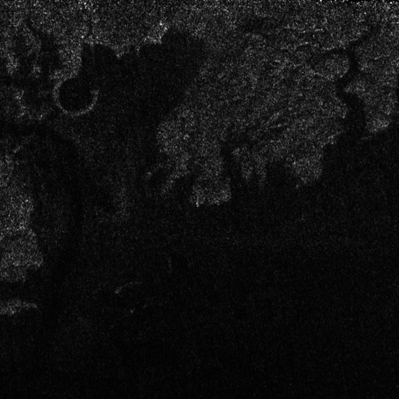
The image above represents a portion of a radar swath obtained from the Cassini orbiter during the T29 Flyby of April 26, 2007. The file name of the original view is BIUQI65N015_D127_T029S01_V02_part2.jpg. Each side of the view represents approximately 100 kilometers. One can discern, in particular, the irregular shape of the coastline as well as the presence of significant drainage channels. One can imagine the potential action of waves at the level of the shoreline. A remarkable circular feature can also be identified. Credit for the original view: NASA/JPL/Cassini Radar Team/Jason Perry. Montage credit: Marc Lafferre, 2024. |
- To get further information on that news, go to: https://news.mit.edu/2024/study-titans-lakes-may-be-shaped-by-waves-0619 and https://www.science.org/doi/10.1126/sciadv.adn4192 .