November 9, 2023: Fractures Or Strike-Slip Faulting In The Exploration Area Of The Dragonfly Rotorcraft ?
Is the external crust of Titan stable or unstable ? Are there fractures in the external crust of the largest moon of Saturn ? That's a major question for planetologists and for exobiologists. An unstable external crust on that intriguing world implies the potential presence of major tectonic events and the potential presence of cryovolcanoes that are likely to spew water, ammonia, hydrocarbons or organics from time to time. A new study entitled "Exploring the initial landing site area of Dragonfly on Titan: Insights into shear failure and strike-slip faulting at Selk crater", proposed by Liliane M.L. Burkhard and Sarah A. Fagents and published in Icarus in the volume 406 evaluates the potential of fracturing of the external crust of the Opaque Moon due to the tidal forces related to the variations in the distance between the Gas Giant Saturn and Titan. The researchers of the study focus their attention on the area where the probe of the Dragonfly mission will land in 2034. The Dragonfly rotorcraft will have the opportunity to explore an area of dunes as well as the area of the Selk crater. Will it identify fractures, shear failure or strike-slip faulting during that ambitious mission in the harsh environment of that intriguing moon ?
Thanks to the Radar Mapper of the Cassini spacecraft in particular, we have been in a position to identify remarkable features on the surface of the giant moon of the Ringed Planet. There is a sharp contrast between relatively bright areas and relatively dark areas in the low or middle latitudes. The relatively dark areas found in the low or middle latitudes turn out to be dominated by linear and parallel dunes extending over long distances. The relatively bright areas found in the low or middle latitudes may be richer in water ice or may contain a complex topography with hills, mountains or fractures. The radar views which have been taken from the Cassini orbiter from the start of the Cassini-Huygens mission in the Saturn System in 2004 to the end of the Cassini-Huygens mission in that system in 2017 have clearly revealed that the high latitudes of Titan unveil lakes, seas and rivers. The contrast in the distribution of lakes, seas and rivers on Titan is surprising. How can we explain that the lakes, seas and rivers are mostly found in the high latitudes of the moon ? How can we explain that the north polar region appears to be the most humid area of Titan ? Is that configuration related to tectonic phenomena ?
Some researchers advance that the numerous pools present in the high latitudes of the northern hemisphere could be connected to a subsurface layer of liquid methane or liquid ethane or could be connected to pockets of liquid methane or liquid ethane. A thinner crust at the level of the polar areas could have facilitated that hypothetical network of liquid hydrocarbons between the underground and the surface. The north polar area appears relatively bright in the infrared or near-infrared views obtained from the Cassini spacecraft. One can imagine that the crust or the soil in the area of the lakes, seas and rivers in the northern hemisphere is relatively rich in water ice. Rocks, stones or pebbles dominated by water ice can be envisaged on the surface of Titan. The Huygens probe had clearly revealed a surface composed of eroded stones or pebbled that may be rich in water ice and that may also contain hydrocarbons or organics like methane, ethane, propane or acetylene. Like on Earth, the composition of the surface can vary depending on the region. The opaque atmosphere of Titan prevents us from identifying the surface from outer space in the visible spectrum but one can guess or imagine what one could find on the surface by analyzing worlds like Tethys, Dione, Rhea, Iapetus or Europa.
The planetologists or geologists are in a position to determine the potential characteristics of an icy surface or the potential characteristics of an icy crust in a harsh environment where ambient temperatures evolve around -179 degrees Celsius, -290 degrees Fahrenheit or 94 Kelvin. Fractures or faults within the external crust can be easily imagined. Major fractures in the south polar region of the tiny moon Enceladus have been clearly observed from the Cassini orbiter for instance. Those fractures unveil cryovolcanic features or geysers which spew molecules like water ice, hydrocarbons and organics into outer space. Those fractures demonstrate the gravitational influence of Saturn and the other moons that produce tidal forces that can be particularly strong for a world that evolves close to the Gas Giant. The perfect exemple is Io, the volcanic moon of Jupiter. Io regularly produces major volcanic eruptions thanks to the tidal forces related to Jupiter and the other moons of the Gas Giant. Titan evolves much farther from the Gas Giant around which it revolves so that the tidal forces related to Saturn appear less pronounced. The elliptical orbit of Titan implies variations in the tidal forces related to Saturn.
Moons like Tethys, Dione, Rhea or Iapetus can also fuel the internal activity of Titan. That world may contain a subsurface ocean dominated by liquid water beneath its icy crust. That internal layer or ocean is likely to engender instabilities within the external crust implying the potential presence of fractures, cryovolcanoes or geysers. Liliane Burkhard who is the lead author of the study upon the potential of shear failure and strike-slip faulting in the exploration area of the Dragonfly rotorcraft and in the area of the Selk crater and who is a research affiliate at the Hawai'i Institute of Geophysics and Planetology in the UH Manoa School of Ocean and Earth Science and Technology is particularly interested in the potential shear deformation of the external crust because that type of phenomenon can facilitate the exchange of surface and subsurface materials. That's a configuration that can facilitate the emergence of life. The presumed ocean dominated by liquid water may be found at a depth representing tens of miles. The researchers of the study have been in a position to evaluate the likelihood of fractures, shear deformation or strike-slip-faulting in the exploration area of the Dragonfly rotorcraft.
Tectonic phenomena will be closely linked to the characteristics of the external crust. Water ice can crack, fault and deform for instance. Deformation processes may be present on Titan today but it is unlikely that the Selk crater contains fractures or faults because that configuration would imply very high pore fluid pressures and a low crustal coefficient of friction for shear failure. Therefore, the Dragonfly rotorcraft should be in a position to land relatively safely inside the crater. The planetologists have determined that there are optimal shear failure conditions within the shallow subsurface of the giant moon due to the deduced presence of a porous ice blanket saturated with liquid hydrocarbons. The Selk crater area may not have the conditions which can engender shear deformation due to a level of pore fluid pressure that is not high enough or due to a coefficient of friction of the icy crust that is not low enough. The calculation of the diurnal tidal stresses that can engender a deformation of the surface or the crust was performed with methods based on the Coulomb failure criterion and on the numerical model SatStress. The outcome is reassuring in the prospect of the Dragonfly mission !
In the research work of Liliane Burkhard and her collaborator, the extracted stresses were obtained along one line of latitude that is to say the latitude of 5 degrees north and from the longitude of 155 degrees east to 165 degrees east. Several types of geologic terrain units were studied by the team at that latitude. The researchers had to produce their work on the basis of data which are not very precise. The Cassini orbiter has captured a huge amount of data regarding the surface or the topography of Saturn's largest moon but the infrared or near-infrared views and the radar views have generally a limited resolution compared to what we can obtain from our satellites which evolve in a low orbit around the Earth for instance. During the orbital dance of the Cassini spacecraft in the Saturn System, the distance between the orbiter and the giant moon when the views were acquired could vary so that the resolution was not uniform which makes the analysis of the surface or the topography more complicated or less simple. The overall shape of the dunes dominating the relatively dark areas of the low or middle latitudes has been clearly identified with the Radar Mapper of the Cassini spacecraft but the small-scale structures within the dunes can't be seen in the radar views.
The major lakes, seas or rivers have also been clearly identified from the Cassini orbiter thanks to infrared or near-infrared data and thanks to radar data in particular but the small pools of liquid methane or liquid ethane can't be identified. That's also the case for the narrow rivers or streams connected to the major rivers, to the major pools or to the major seas. The radar views have shown that the environment of the giant moon is remarkably diverse with surface features that can be compared to karstic landforms on Earth or to tectonic features that may be associated with strike-slip faulting phenomena. Methane rain and prevailing winds can have a strong influence on the shape of the landscape via erosional processes. The aerial views obtained from the Huygens probe during its atmospheric descent had clearly revealed bright hills containing a network of dark channels that may become active from time to time when strong rainfall events associated with methane molecules occur. Tectonic fractures in those hills found in the low latitudes of the southern hemisphere can also be envisaged. The Huygens probe had revealed a strong contrast between those bright hills and a brown or dark plain that seemed to be relatively flat. The brown or dark plain may be saturated with methane and may be significantly different from the bright hills in terms of composition.
|
|
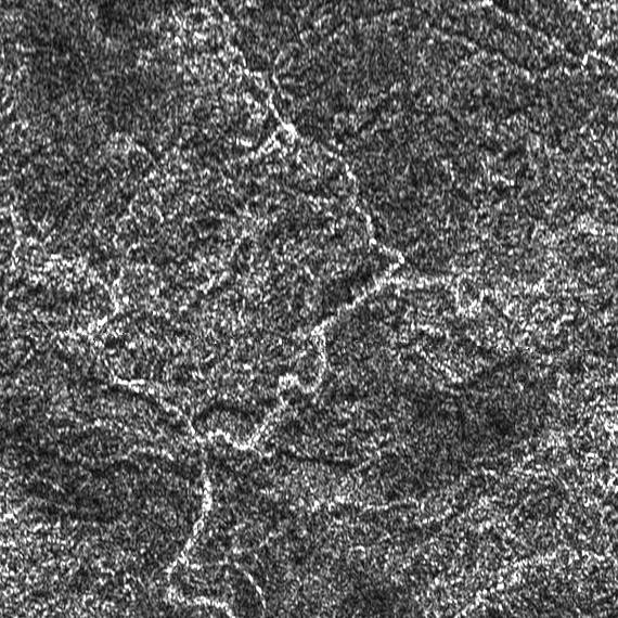
This image represents a portion of a radar swath acquired from the Cassini orbiter during the T13 Flyby of April 30, 2006. The file name of the original view is BIUQI11S116_D082_T013_V01_part1.jpg. Each side of the image is about 100 kilometers long. One can notice a network of bright sinuous lines that may represent canyons, ancient rivers or fractures in a relatively bright area dominated by an irregular landscape. Credit for the original view: NASA/JPL/Cassini RADAR team/Jason Perry. Montage credit: Marc Lafferre, 2023. |
- To get further information on that news, go to: https://www.soest.hawaii.edu/soestwp/announce/news/geologic-faulting-titan-ganymede/ and https://www.sciencedirect.com/science/article/abs/pii/S001910352300341X?dgcid=author.