May 1, 2021: Titan May Contain Active Volcanoes Like Many Worlds In The Solar System
Saturn's largest moon Titan appears to be a captivating world which looks like the Earth to a certain extent. The Cassini spacecraft as well as the Huygens probe have revealed a dynamic world unveiling seas, lakes or rivers. The infrared or near-infrared views of the giant moon obtained during the orbital dance of the Cassini orbiter during the long Cassini mission in the Saturn System have clearly revealed the presence of dynamic meteorological processes such as cloud systems or cyclones. The clouds of that enigmatic world can engender rainfall events. The rain of Titan which falls relatively slowly to the surface due to the relatively low gravity can be composed of methane or ethane. Methane and ethane can be present in their liquid form on the surface in a relatively stable way. Planetologists can draw a parallel between the meteorological cycle of Titan based on liquid methane and the meteorological cycle of the Earth based on liquid water. There may also be internal sources to the relatively high concentration of methane in the Titanian atmosphere. Are there topographic fractures, geysers or cryovolcanoes where methane molecules or ethane molecules erupt ?
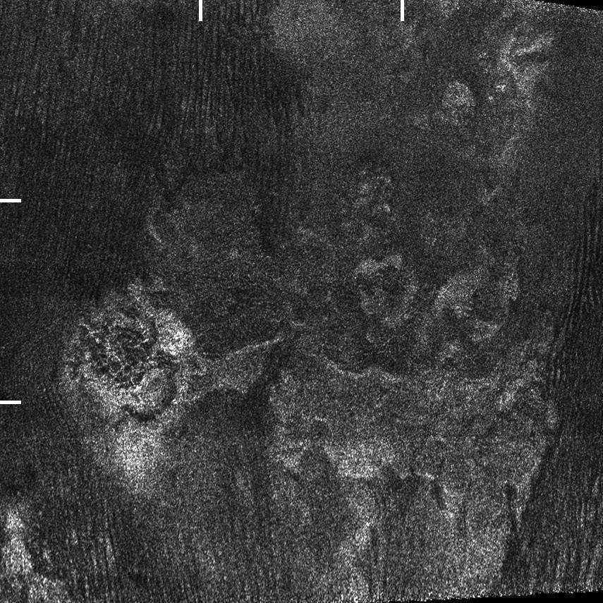
The radar views or the infrared or near-infrared views acquired from the Cassini orbiter during its long mission in the Saturn System from 2004 to 2017 have clearly revealed circular features, potential calderas, fractures, mountains or potential cryovolcanoes on Titan. However, it appears difficult to conclude that there are active cryovolcanoes on the Opaque Moon today. Planetologists have identified several topographic features which may represent cryovolcanoes on that world where the environmental temperature at the level of the surface oscillates around minus 179 degrees Celsius, minus 290 degrees Fahrenheit or 94 Kelvin. Sotra Patera and Doom Mons are among the potential cryovolcanic features identified on Saturn's largest moon today. Sotra Patera is a large depression that may represent a caldera. Doom Mons is a relatively circular mountain that may correspond to a cryovolcano. The structure reveals two peaks and a multitude of craters. One peak is approximately 1,000 meters high (About 1 kilometer high or about 0.62 mile high) and the other one is approximately 1,450 meters high (About 1.45 kilometers high or about 0.9 mile high). The deepest crater appears to be Sotra Patera with a depth of about 1,700 meters (About 1.7 kilometers or about 1.06 miles).
The area of Doom Mons and Sotra Patera is connected to a topographic feature which resembles a very wide stream whose length represents at least 200 kilometers. That feature has been named Mohini Fluctus. Mohini Fluctus may be the outcome of a major flooding event emanating from the potential cryovolcanic feature represented by Doom Mons and Sotra Patera. Is Mohini Fluctus the outcome of a stream of lava related to a huge cryovolcanic event in the recent past ? Is Mohini Fluctus the outcome of a meteoritic impact ? Any meteoritic impact can engender a transient lake of molten material that can generate rivers. Planetologists must determine the exact nature of the soil of the area where the potential impact has occurred in order to deduce the potential characteristics of the presumed stream of molten material. The crust of Titan is probably rich in water ice and must also contain a significant concentration of hydrocarbons and organics. One can notice in particular that Doom Mons and Sotra Patera are located in an area where some systems of dunes can be found. A portion of Mohini Fluctus is cut by relatively dark dunes. Those dunes must be rich in organics, hydrocarbons or tholins. They clearly show that erosion is particularly active in the region of those presumed cryovolcanic features.
Doom Mons appears to be located at a relatively low latitude in the southern hemisphere. The dark areas of the low or mid-latitudes of the Opaque Moon tend to be dominated by linear and parallel dunes extending over long distances. Those dunes demonstrate that the low or mid-latitudes of Titan are relatively dry and that winds can sculpt the landscape in a remarkable way. The dunes of Saturn's largest moon are reminiscent of the Seif Dunes found in the Namib Desert on Earth. The views obtained from the Huygens probe during its atmospheric descent on January 14, 2005 have clearly shown that the dark areas of the low or mid-latitudes are not seas or oceans of methane or ethane. The low or mid-latitudes of Titan unveil a sharp contrast between relatively dark areas dominated by dune fields and relatively bright areas which may represent mountains, hills or fields of ice. The aerial views acquired from the Huygens probe had revealed bright hills containing dark channels and a dark or brown plain marking a sharp contrast with those bright hills. The famous color view taken from the surface unveils pebbles or strongly-eroded stones implying that the probe may have landed onto an ancient brook, stream or river.
The network of dark channels identified from the Huygens probe during its parachuted descent and located in the relatively bright hills of Adiri may be related to meteorological phenomena. There must be heavy rainfall events from time to time in the area. At the time of the observations, the dark channels were probably empty or dry. Seasonal factors must play a key role in the dynamics of those dark channels. Dynamic and transient cloud systems had been observed at a low or mid-latitude of the Opaque Moon in 2010. Those meteorological phenomena which are completely unusual at a low or mid-latitude on Titan demonstrate that heavy rainfall events can take shape from time to time during the long Titanian year. A year on Titan represents, in fact, almost 30 Terrestrial years and a season on that giant moon represents approximately 7 Terrestrial years. The Cassini orbiter has acquired a huge amount of data regarding the surface or the atmosphere of Titan during its long mission in the Saturn System but that mission has represented less than a Titanian year. Therefore, our knowledge about the meteorological cycle of Saturn's largest moon is still incomplete.
The dark channels of the bright hills of Adiri observed from the parachuted probe likely represent drainage channels related to precipitation events but they may also represent fractures related to tectonic phenomena or drainage channels related to cryovolcanic events. What can be the nature of the potential liquid found in the channels of Adiri ? If the liquid is the outcome of rainfall events, its composition is likely dominated by methane. Methane, ethane and propane are three hydrocarbons that can be found in their liquid form on the surface of Titan and methane is the second most abundant compound in the atmosphere of that world. Methane can represent about 5 percent of the composition of the air in the Troposphere of the giant moon. It can engender clouds which can produce rainfall events. That's also the case for ethane but ethane is less concentrated in the atmosphere. The liquids can in fact contain a mixture of methane, ethane and dissolved nitrogen. Their composition can be closely related to the season, the latitude or the area. If there are internal sources to the various channels found in the bright hills of Adiri, the composition of the liquid can be more complex with different types of hydrocarbons or organics for instance.
The landscape of Titan is remarkably varied like the landscape of the Earth. The resolution of the radar views or the resolution of the infrared or near-infrared images acquired from the Cassini spacecraft are quite limited so that some features of the landscape can appear difficult to interpret. The radar images obtained with the Radar Mapper of the Cassini orbiter have clearly demonstrated that there are lakes, seas and rivers on Titan but those lakes, seas or rivers are mostly found in the high latitudes or in the polar regions of the giant moon. The low or mid-latitudes appear relatively dry. The contrast is really remarkable and difficult to explain. How can we explain the dichotomy in the distribution of lakes, seas and rivers on Titan ? How can we explain that the high latitudes of the northern hemisphere appear much more humid than the high latitudes of the southern hemisphere ? Are those lakes, seas and rivers exclusively related to meteorological factors ? Are there internal sources to the lakes, seas and rivers observed in the high latitudes of the northern hemisphere ? Some relatively circular lakes with sharp rims may in fact represent calderas or ancient cryovolcanoes.
Some researchers have advanced that the external crust may be thinner in the north polar region so that a network of liquid methane between the surface and the underground can be envisaged or imagined. Are some lakes, seas or rivers found in the high latitudes of the northern hemisphere related to a network involving pockets or seas dominated by liquid methane beneath the external crust ? If there are internal sources to those lakes, seas and rivers, one can better understand why methane is present in relatively high concentrations in Titan's atmosphere today and why the area is more humid than the areas found at lower latitudes. Let's point out that methane tends to disappear over time under the action of ultraviolet light from the Sun. The observations of the tiny moon Enceladus have clearly shown that cryovolcanism can be remarkably strong in the system of Saturn. Several geysers or cryovolcanoes have been identified in the fractures found in the south polar region of Enceladus. They demonstrate that the polar regions can be remarkably active on an icy world. Can we imagine the same type of phenomenon, involving methane molecules, in the north polar region of Titan ?
|
|
The image above represents a portion of a radar swath of Titan's surface obtained during the T25 Flyby performed by the Cassini orbiter on February 22, 2007. The area unveils Doom Mons, a potential cryovolcano located at a relatively low latitude on Saturn's largest moon. One can also notice Mohini Fluctus, a topographic corridor emanating from the presumed cryovolcano. That feature may represent an ancient stream of lava. Each side of the view is 300 km long. Bright marks of graduation were incorporated into the original view for the scale. There is a separation of 100 km between each mark of graduation. Credit for the original view: NASA/JPL/Cassini Radar Team/Jason Perry. Credit for the incorporation of the marks of graduation into the original view: Marc Lafferre, 2021. |
- To get further information on that news, go to: https://en.wikipedia.org/wiki/Doom_Mons .