February 26, 2018 : The Identification Of Seif Dunes At Low Latitudes And Of Lakes Or Seas At High Latitudes On Titan Were Marking Discoveries During The Cassini Mission
Prior to the Cassini-Huygens mission, Saturn's largest moon Titan gathered all the ingredients to draw the attention of researchers and of the general public. The opaque atmosphere of the giant moon prevented us from discerning surface features in the visible spectrum. Some researchers had hypothesized the presence of oceans or seas of methane or ethane on the presumed icy crust of the natural satellite. Some surface features of the Hazy Moon could be identified in the infrared or near-infrared spectrum. The Cassini spacecraft was going to bring new clues or answers regarding surface features or atmospheric features on Titan thanks to the Radar Mapper or the Visual and Infrared Mapping Spectrometer.
As soon as the first part of the Cassini-Huygens mission in 2004, the infrared or near-infrared images acquired from the Cassini orbiter revealed a remarkable contrast between low-albedo areas and high-albedo areas on the Orange Moon. Low-albedo areas were mostly found at low latitudes or at mid-latitudes. Some planetologists believed that the low-albedo regions represented seas or oceans of methane because the atmosphere of Titan, mainly composed of nitrogen like the atmosphere of the Earth, contains a significant fraction of methane. Researchers knew that the environmental temperature at « sea level » was around minus 180 degrees Celsius, minus 292 degrees Fahrenheit or 93 Kelvin. They also knew that the atmospheric pressure on the ground was higher than that of the Earth at sea level.
In that harsh environment, some molecules like methane, ethane or propane can appear in their liquid form. Thus, planetologists were aware that the hypothesis regarding the presence of lakes, seas, oceans or rivers of hydrocarbons on the Opaque Moon had solid foundations. However, some scientists pointed out that the areas unveiling a low reflectivity in the infrared or near-infrared spectrum at low latitudes or mid-latitudes were not uniform enough or were not dark enough to represent pools of liquid methane or liquid ethane. The Huygens probe was going to clarify the debate regarding the nature of the low-latitude regions. On January 14, 2005, the Huygens probe performed its historical plunge into Titan's atmosphere and obtained panoramic views of the landscape during the atmospheric descent. The probe proposed by the European Space Agency was going to land at a low latitude of Titan's southern hemisphere.
Would the Huygens probe collect panoramic views of lakes, seas or rivers of methane ? Would it collect views of a dry landscape devoid of any liquids ? Would the Huygens probe land onto a lake, onto a sea, onto a river or onto a dry soil ? Some researchers or citizens had imagined seas or oceans where we could sail or surf with the appropriate outfit. The possibility of capturing images of lakes, seas or oceans had captivated the imagination of a lot of people and we were going to get an answer or major clues if the probe successfully landed. The images acquired from the ground would probably be meaningful. On TV, we first saw panoramic views, captured during the atmospheric dive of the parachuted probe, which revealed intriguing features on the surface. Viewers could watch dark drainage channels within a bright area made of hills or mountains. They could notice a sharp contrast between the bright hills composed of the dark sinuous channels and a dark, brown or red plain.
In fact, from the aerial views, it was far from being easy to understand exactly what we were seeing on Titan's surface. Was the network of dark channels found on the bright hills or mountains related to meteorological phenomena ? Was it the outcome of rainfall or springs like typical rivers or drainage channels on Earth ? Did the dark sinuous channels correspond to dried-up channels, to canyons ? Did those channels correspond to fractures ? Were those channels related to a cryovolcanic activity ? Since the images were in black and white, it was not obvious to analyze the landscape in the best way. Some specialists believed that the dark, brown plain, marking a sharp contrast with the bright terrain, represented a sea of methane or ethane. An aerial view of the area struck some viewers because the landscape was reminiscent of a typical coastline of our planet, in particular the shoreline of the French Riviera where the mountains or hills fall to the sea.
The Huygens probe was going to land onto a solid or liquid surface of the Adiri/Shangri-La region. Adiri corresponds to a bright patch in the infrared or near-infrared views obtained from the Cassini orbiter whereas Shangri-La represents a low-albedo area at the same wavelengths. The Huygens probe was going to land at a particularly low latitude in the southern hemisphere of the Hazy Moon. In 2005, the southern hemisphere was experiencing the Summer season whereas the northern hemisphere was experiencing the Winter season. Were we going to land onto a bright area or onto a dark area ? The touchdown was perfect and at the end of the day, we could see the first image taken from the surface of the Opaque Moon. The probe was not floating on a sea or lake of methane but the view revealed an exotic landscape with strongly eroded stones or pebbles. It seems that the Huygens module had landed onto an ancient river bed or stream.
Thanks to the Cassini probe, we were in a position to say that the dark areas found in the low latitudes and marking a sharp contrast with bright areas didn't represent seas or oceans of methane or ethane. However, the dark channels found in the bright hills or mountains of Adiri may correspond to drainage channels related to meteorological processes and methane rainfall which implies that the dark, brown plain may sometimes be filled with liquid methane. Researchers clearly realized that the meteorology of Titan is particularly dynamic like the meteorology of the Earth. Some data we had recorded revealed that the impact of the probe had engendered a relatively strong release of methane. The surface of the dark, brown plain must absorb a lot of methane. So, there may be a threshold for flooding in the area. During the long mission of the Cassini orbiter, infrared or near-infrared data have shown that clouds are rarely present at low latitudes on Titan. One can observe large formations of clouds of hydrocarbons in the transition period from the Winter season in the northern hemisphere to the Spring season in the northern hemisphere. Thus, we may encounter strong showers of liquid methane or liquid ethane in the period of the equinox.
Later, after the event of the historical touchdown, radar data of the low latitudes, obtained from the Radar Mapper of the Cassini spacecraft, were released. We were astonished to observe remarkable surface features in the low-albedo areas of the low latitudes that we immediately called the « Cat Scratches ». In fact, the Cat Scratches represented linear and parallel dune fields extending over long distances. Those dunes were reminiscent of the Seif Dunes found in the Namib Desert on Earth. Those linear and parallel dunes tell us a lot upon the orientation and the action of prevailing winds on Saturn's largest moon. We could analyze the interactions between the bright surface features and the dark dunes. The orientation of the dunes can be diverted by bright topographic obstacles. Thanks to radar data obtained from the Radar Mapper of the Cassini orbiter, we know, now, that the dark areas of the low latitudes are dominated by linear and parallel dunes extending over long distances. Researchers advance that the dunes of Titan may be rich in organics or hydrocarbons like benzene. There may be what we call tholins on Titan's surface.
Researchers performed a major discovery in 2005 with the identification of Ontario Lacus, the first extraterrestrial lake or sea identified in the Solar System. The kidney-shaped pool of liquid hydrocarbons was identified at a high latitude in the southern hemisphere. Multiple dynamic clouds were clearly observed in the region of Ontario Lacus. There are probably strong evaporation processes and precipitation processes in the south polar region of Titan during the Summer season. In 2006, we identified lakes or seas at a high latitude in the northern hemisphere of the Opaque Moon. We realized that the north polar region or the high latitudes of the northern hemisphere represented the most humid area on Titan. Researchers also identified a giant ethane cloud engulfing the north polar region. The Winter season in the northern hemisphere came to an end in 2009 with the equinox marking the start of the Spring season in the northern hemisphere. Why are the lakes and seas concentrated in the polar areas of the giant moon ? Is there an underground reservoir of methane or ethane feeding the lakes or seas ? Is there a methane-based life in the wet areas of the Orange Moon ?
In 2012, researchers revealed the presence of a vortex evolving at a high altitude above the south polar region experiencing the Autumn season. Will the level of Ontario Lacus grow or will the size of Ontario Lacus increase as the Winter season develops in the area ? Will the level or the size of the north polar lakes or seas decrease as the Summer season develops in the area ? The meteorology and the dynamics of Titan's atmosphere clearly appear complex and captivating. Complex hydrocarbons or organics like vinyl cyanide or acrylonitrile can take shape in the atmosphere. Planetologists try to precisely determine the nature and the dynamics of the liquids evolving in the lakes, seas or rivers of Titan. In 2014, researchers revealed the puzzle of the « Magic Island », a new bright feature, in radar data, resembling an island in the famous lake or sea Ligeia Mare. That feature had suddenly appeared. It rapidly dissipated and then completely disappeared. What was it ? A giant iceberg ? A cyrovolcanic island ? A field of strong waves ? A field of bubbles ? Nobody knows today !
|
|
|
|
|
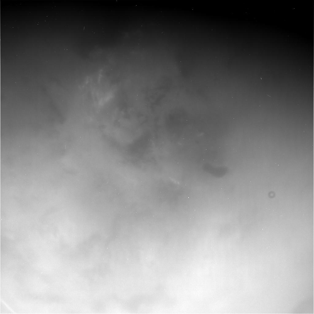
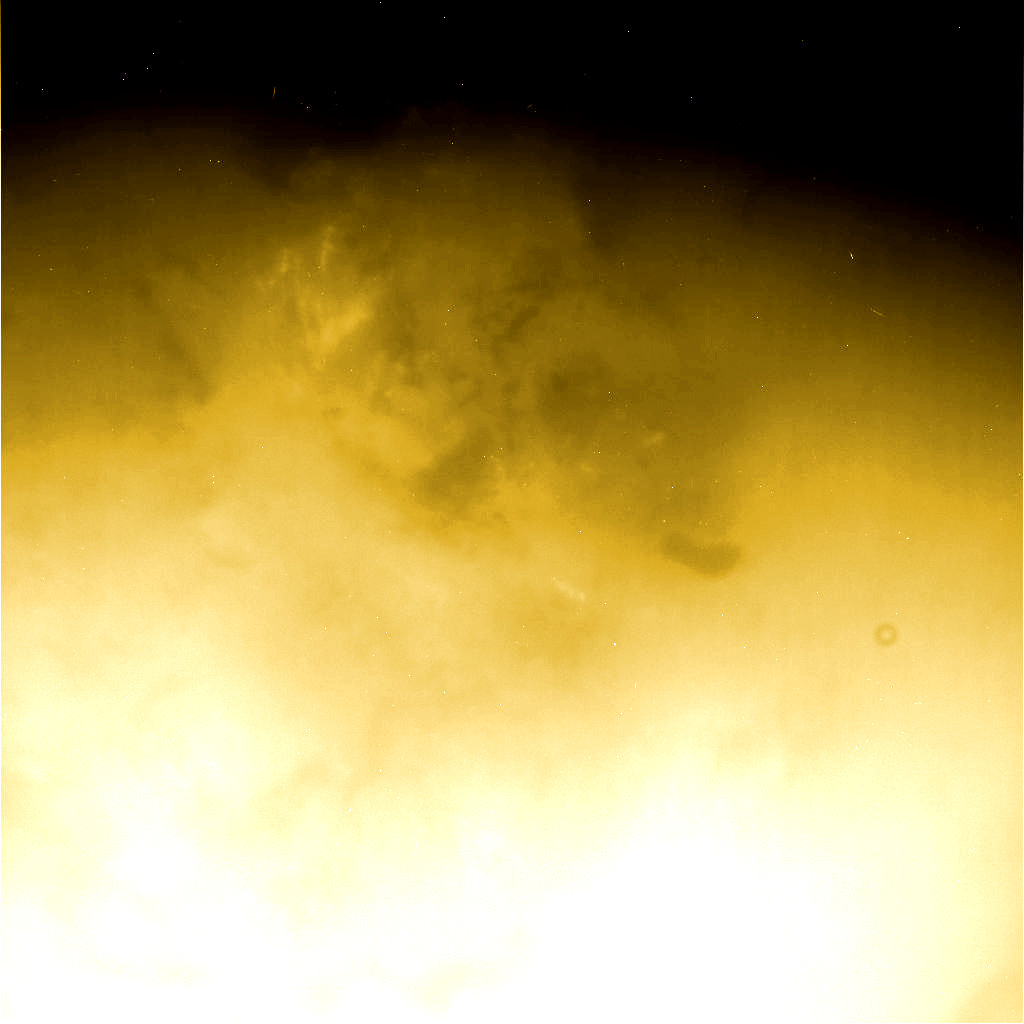
The image in the upper part of this table represents a raw image of Titan unveiling the area of Ontario Lacus. The view was acquired on June 6, 2005 from the Cassini spacecraft using the IRP0 and the CB3 filters. The file name of the image is N00035074.jpg. The photo has not been validated or calibrated. A validated and calibrated view will be archived with the NASA Planetary Data System. One can notice a system of bright clouds in the upper left part of the image. One can also notice the dark and uniform patch of Ontario Lacus which looks like a foot. The image in the lower part of the table represents the same view with an artificial color and a higher contrast in order to better discern key surface features. Image credit for the
original view: NASA/JPL-Caltech/Space
Science Institute. |
|
|
|
|
|
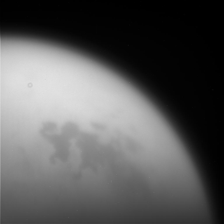
The image in the upper part of this table corresponds to an unprocessed view of a portion of Titan obtained on September 11, 2017. One can clearly discern the shape of a sea or lake found in the high latitudes of Titan's northern hemisphere. The pool of liquids appears dark and uniform. The eye of the Cassini probe can see surface features in the infrared or near-infrared spectrum. The image in the lower part of the table corresponds to a colorized view of the black and white image. Image credit for the
original view: NASA/JPL-Caltech/Space
Science Institute. |

- To get further information on that news, go to: https://saturn.jpl.nasa.gov/mission/top-tens/science-highlights.