Titan News 2010
December 20, 2010: Scientists identify a Potential Cryovolcano on Titan: Sotra Facula
A particular landscape feature made of mountains or hills, craters or pits and flows within the "Tropics" of Saturn's largest moon, Titan, may correspond to a cryovolcano or an ice volcano, according to specialists.
This intriguing landscape feature, located around 15 degrees south latitude, 40 degrees west longitude is known as Sotra Facula. Sotra Facula appears in the optical "H" of the dark Fensal/Aztlan region.
The results of a study suggesting the potential cryovolcanic nature of Sotra Facula were presented on December 14, 2010 at the American Geophysical Union meeting in San Fransisco.
Sotra Facula has been imaged by the radar mapper and the Visual and Infrared Mapping Spectrometer (VIMS) of the Cassini spacecraft. Two radar swaths were, notably, used by researchers to analyze Sotra Facula: the first radar swath showing Sotra Facula was obtained during the T25 flyby on February 22, 2007. The second radar swath unveiling Sotra Facula was acquired during the T28 flyby on April 10, 2007. Sotra Facula appears as a bright patch in the infrared or near-infrared views acquired by the VIMS instrument of the Cassini probe.
The overlap of radar swaths has enabled a USGS group led by Randolph Kirk to generate a topographic map of Sotra Facula as well as a 3-D flyover simulation revealing the topography and the potential nature of the presumed cryovolcano.
It turns out that Sotra Facula is, notably, made of two peaks more than 1,000 meters or 3,000 feet high, deep volcanic craters (if the hypothesis for icy volcanism is confirmed) and finger-like flows. One of the craters or pits is around 1,500 meters (4,921 feet) deep.
Randolph Kirk, who is, notably, a Cassini radar team member and geophysicist at the U.S. Geological Survey (USGS) Astrogeology Science Center in Flagstaff, Arizona pointed out: "When we look at our new 3-D map of Sotra Facula on Titan, we are struck by its resemblance to volcanoes like Mt. Etna in Italy, Laki in Iceland and even some small volcanic cones and flows near my hometown of Flagstaff." He insisted: "It's really this combination of features that makes us think we've found good evidence of a volcano on Titan."
Jeffrey Kargel, a planetary specialist at the University of Arizona, Tucson advanced: "This is the very best evidence, by far, for volcanic topography anywhere documented on an icy satellite." He added: "It's possible the mountains are tectonic in origin, but the interpretation of cryovolcano is a much simpler, more consistent explanation."
The craters may correspond to calderas or simply impact craters which are widespread on the surface of the moons in the outer Solar System. However, Titan is a unique moon, Titan is unlike any other world because Titan is a moon with a deep, thick and opaque atmosphere. As a result, the asteroids, comets or meteorites which penetrate into Titan's atmosphere will tend to partially or completely disintegrate depending on the size or composition of the object.
Thus, it appears that Titan has a relatively young surface with few impact craters or buried impact craters. Moreover, the equatorial or tropical area may undergo strong winds, monsoon events, tropical storms or periodical heavy rainfalls. This is one of the reasons why the cryovolcanic hypothesis can be seriously considered by researchers in the case of a topographic depression, a crater or a pit. Jeffrey Kargel chose his side: "Titan is an extremely sparsely cratered world."..."Cryovolcanism is by far the best explanation, in my view."
The nature of the material expelled in the hypothetical cryovolcanism is still unknown. Contrary to volcanism on Earth and on Io, spewing molten rock or silicate compounds, volcanism on Titan may take shape on the basis of water, mixtures of water and ammonia, carbon dioxide, carbon monoxide, methane, ethane, propane, acetylene, ethylene, benzene or other hydrocarbons.
Titan is thought to be radically different in composition from Earth. Titan may be a differentiated globe with different layers in the interior of the moon and compounds of lower density in the outer layers.
Titan is an exotic world: the Orange Moon is located in the outer Solar System, orbiting at about 1.4 billion km from the Sun. Hence, the energy reaching Titan is particularly low, turning water or carbon dioxide into ice.
It is not surprising that the mean density of the Opaque Moon is well below that of the Earth (around 1.88 g/cm^3 for Titan and approximately 5.5 g/cm^3 for the Blue Planet). The exotic composition of Titan's crust leads scientists to postulate the existence of cryovolcanism or ice volcanism.
Titan may appear in the growing list of moons known to harbor volcanoes, cryovolcanoes or geysers. Io is undoubtedly the most active world in the Solar System: active volcanoes spewing materials made of silicate or sulfur are numerous on this moon of Jupiter. And in the category of active outer Solar System objects, one can mention the moon of Neptune, Triton, which harbors the famous "Black Smokers". Closer to Titan, one can find a unique cryovolcanism on the Saturn moon Enceladus.
It is a weird cryovolcanism because the material expelled emanates from long "Tiger Stripes" in the south polar region of the white, bright, reflective moon. The cryovolcanism of Enceladus may be relatively similar to that of the hypothetical ice volcanoes of Titan, Sotra Facula or Hotei Arcus, as Marc Lafferre, a specialist of Titan, notes.
However, there may be several kinds of volcanoes on Titan, as on our planet. The nature of the material erupting from cryovolcanoes will depend on the geological characteristics of the area and on the strength of energy sources in the interior of the moon. Tidal forces generated by Saturn and the other moons are likely to influence the strength of the cryovolcano, the depth of the energy source and therefore, the nature of the compounds erupting from the cryovolcano. If the presumed cryovolcano Sotra Facula is similar in nature to cryovolcanism on Enceladus, the material expelled may be made of water and icy particles.
Some specialists of Titan advance that cryovolcanism on Titan may account for the continuous or persistent presence of methane in the dense atmosphere of the Orange Moon. Without methane replenishment from internal sources, methane should have disappeared because the lifespan of methane molecules is relatively limited due to the action of ultraviolet light from the Sun. Methane molecules are thought to have a "life expectancy" of roughly 10 million years.
Linda Spilker who is a Cassini project scientist at NASA's Jet Propulsion Laboratory in Pasadena, California seriously considers the hypothesis of methane replenishment via cryovolcanoes. She pointed out: "Cryovolcanoes help explain the geological forces sculpting some of these exotic places in our solar system."..."At Titan, for instance, they explain how methane can be continually replenished in the atmosphere when the sun is constantly breaking that molecule down." She also underlines: "The cryovolcano offers a perfect opportunity to get that methane gas from the interior of Titan into the atmosphere."
Are the methane/ethane clouds of Titan, notably concentrating in the polar regions of Titan, related to cryovolcanic eruptions or meteorological cycles? Most scientists favour the meteorological cycle of hydrocarbons although some cloud outbursts may be associated with geysers or cryovolcanoes like on our planet. The recent finding of elongated clouds in the Tropics which are usually devoid of cloud formations also raises the cryovolcanic hypothesis. The presence of Sotra Facula at a relatively low latitude strengthens this hypothesis which remains weak, however.
If there is a subsurface or subterranean ocean on Saturn's largest moon, one can consider convection movements, upward pressures, fractures within the external crust and potential geysers or cryovolcanoes, as Marc Lafferre notes.
Some scientists like Jonathan Lunine have envisaged the possibility of a subsurface ocean made of ammonia, water or mixtures of water and ammonia. The analysis of infrared or near-infrared data from the VIMS instrument suggests that the flows emanating from Sotra Facula are different in composition from the surrounding terrain. They may be composed of water ice, ammonia ice, frozen carbon dioxide, covered by hydrocarbon compounds.
If the underground of the Orange Moon is active with liquid layers, one might consider the exobiological hypothesis. The lifeform thriving underground may be composed of the liquid or solvent in which it evolves. In other words, if the "root liquid" is water, it may be a water-based life and if the "root liquid" is methane or ethane, it may be a methane/ethane-based lifeform.
The presumed replenished methane may also recombine in the upper atmosphere to form very complex carbon-made molecules or even the ingredients of life as recent findings suggest. Some molecules floating in the upper atmosphere may contain about 1,000 carbon atoms.
The flows observed in Sotra Facula may result from meteoritic impacts, methane or ethane rain or cryolava eruptions. The debate continues and scientists will have to continue monitoring the area in order to detect any sign of active cryovolcanism. Sotra Facula appears, today, as the best candidate for cryovolcanism.
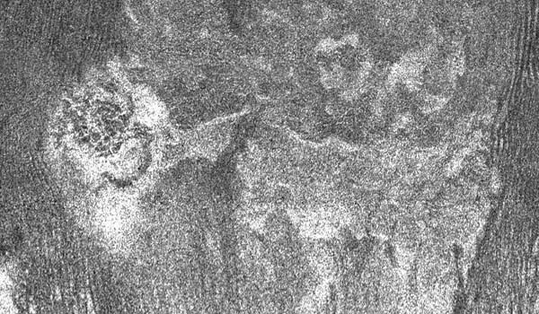
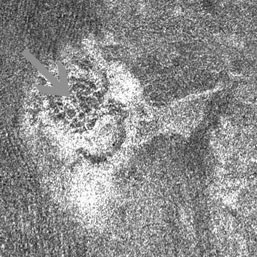
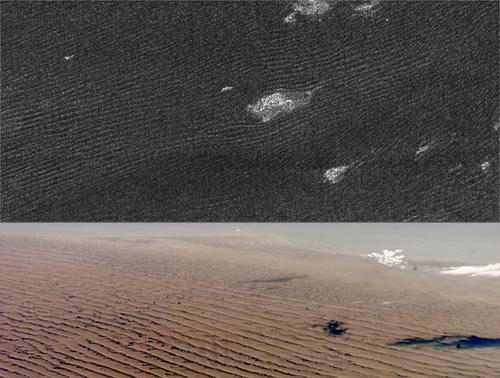
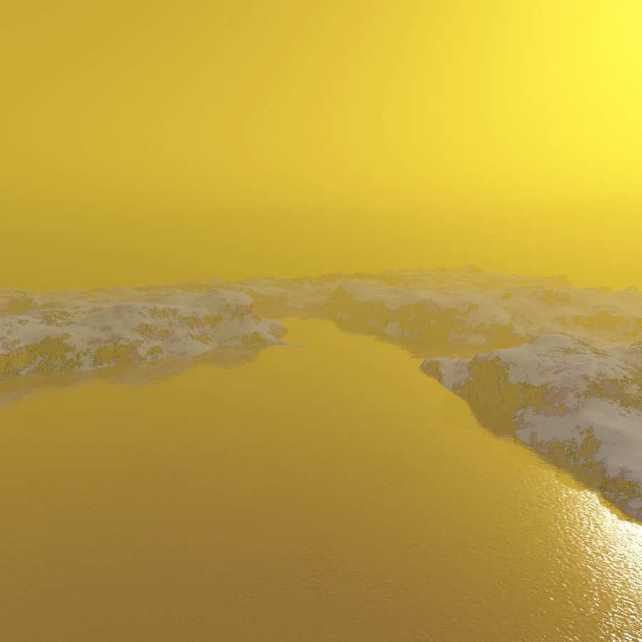
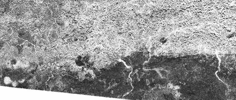
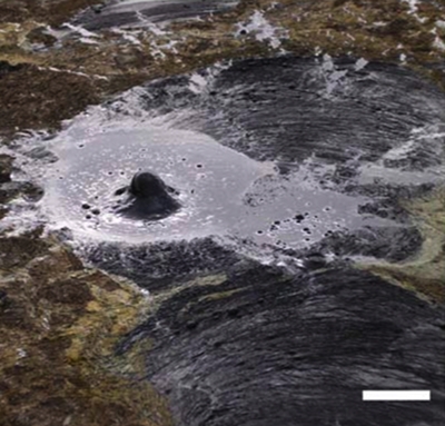
The radar image above shows the presumed cryovolcano Sotra Facula. The radar portion was extracted from the radar swath obtained by the radar mapper of the Cassini spacecraft on February 22, 2007, during the T25 flyby. Sotra Facula appears particularly bright in the radar view suggesting an irregular terrain and a reflective material. Several pits or craters and flows can be seen in this view, as well. Radar Image Credit: NASA/JPL
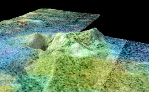
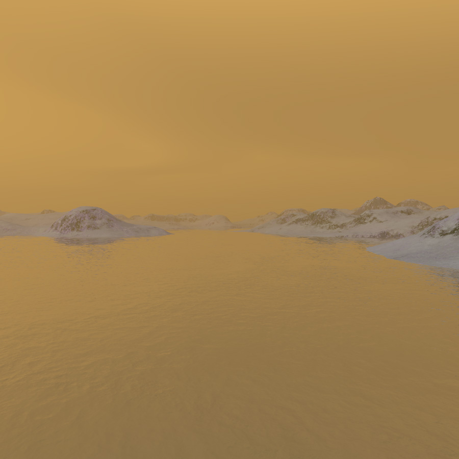
The simulated view of Sotra Facula, above, is part of an animated flyover generated by a USGS team led by Randolph Kirk. One can notice, notably, the high peaks of Sotra Facula as well as a big crater. Image credit: NASA/JPL-Caltech/USGS/University of Arizona
 |
 |
- To get more information on that news, go to: http://saturn.jpl.nasa.gov/news/newsreleases/newsrelease20101214, http://www.space.com/scienceastronomy/titan-ice-volcano-cassini-101214.html, http://saturn.jpl.nasa.gov/photos/imagedetails/index.cfm?imageId=2530, http://saturn.jpl.nasa.gov/photos/imagedetails/index.cfm?imageId=2683 and http://www.space.com/scienceastronomy/saturn-moon-titan-atmosphere-life-ingredients-101007.html.
October 7, 2010: Cloud Abundance May be Diminishing in the North Polar Region as the Spring Season Advances
Since the arrival of the Cassini/Huygens spacecraft at the Saturn System in mid-2004, the instruments of the Cassini probe have unveiled a particular climate and a complex meteorology on the Orange Moon Titan.
Clouds, lakes and seas tend to appear in the polar regions or in the high latitudes of Saturn's largest moon. And the equatorial or tropical areas seem to be mostly dry, dominated by dune fields, linear and parallel dunes or Seif Dunes. How to explain the surprising concentration of clouds and liquid bodies in the polar regions of the Opaque Moon ?
The in-depth survey of Titan's climate and meteorology since July 2004 allows scientists to better understand the development, the dynamics and the distribution of cloud formations in the harsh environment of the Saturn moon.
A team led by Sébastien Rodriguez, a Cassini team collaborator working at Université Paris Diderot, France, has studied more than 2,000 VIMS (Visual and Infrared Mapping Spectrometer) views to generate the first long-term analysis of Titan's weather.
Sébastien Rodriguez and his collaborators found significant atmospheric changes between July 2004 and April 2010. The observations in July 2004 occured in the first half of the summer season in the southern hemisphere and the observations in April 2010 occured at the beginning of the spring season in the northern hemisphere.
At first sight, the seasons seem to play a key role in the meteorology on Titan. The Titan year lasts approximately 29 Earth years and a season lasts about seven Earth years. Titan's orbit around the Sun is elliptical or eccentric, orbiting at a mean distance of about 1.43 billion km or 890 million miles from the Sun. At perihelion, the moon is 1,353,572,956 km or 841,071,241.1 miles from the Sun and at aphelion, it is 1,513,325,783 km or 940,337,045.7 miles from the Sun that is approximately 11.80% farther from the Sun implying significant variations in the solar energy received.
Moreover, the obliquity of the moon is higher than that of the Earth with, approximately, a 27-degree inclination of the rotation axis to the normal of the orbital plane involving stronger changes from one season to the following season.
Sébastien Rodriguez and his team have been in a position to determine that, over the period ranging from July 2004 to April 2010, the cloud systems took shape in three distinct areas: dynamic cloud systems regularly appeared in the south polar region near Ontario Lacus or Mezzoramia. The highest concentration of clouds was found in the north polar region where big lakes and seas have been clearly spotted. A large ethane cloud resembling a hurricane and engulfing the north polar region was identified.
Transient and elongated clouds resembling Cirrus-like clouds have also been found in the mid-latitudes of the southern hemisphere, along a narrow belt around 40 degrees south latitude.
On the basis of the observations, scientists presumed that the cloud asymmetry between the north polar region and the south polar region is related to shifts in seasons and the orbital parameters.
The clouds will tend to accumulate more in the polar region of the hemisphere where it is winter and there will be more evaporation in the polar region of the hemisphere where it is summer. The southern hemisphere experienced the summer season until the equinox of August 2009, when the Sun shone directly over the equator.
The clouds on the Opaque Moon have been well identified with the Visual and Infrared Mapping Spectrometer (VIMS) of the Cassini Spacecraft in the infrared or near-infrared wavelengths.
The clouds observed in the north polar region appear to be primarily made of ethane and aerosols forming from the stratosphere down to the troposphere. On the other hand, the clouds observed in the south polar region appear to form from methane molecules from the surface up to the troposheric layer.
Since the equinox of August 2009 which marks the beginning of Spring in the northern hemisphere and the beginning of the Autumn season in the southern hemisphere, and on the basis of recent images, cloud activity appears to have decreased near the poles of Titan. One can also mention that these particular areas had been heavily overcast until 2008 during the summer season in the southern hemisphere.
Some scientists anticipate that the cloud systems are going to accumulate in the south polar region in the coming years as the winter season approaches and that the clouds in the north polar region will progressively dissipate or get thinner letting a clearer sky. We may also start to observe transient, elongated clouds in the mid-latitudes of the northern hemisphere as the summer season approaches.
Sébastien Rodriguez advanced: "However, we are now seeing evidence of a seasonal circulation turnover on Titan - the clouds at the south pole completely disappeared just before the equinox and the clouds in the north are thinning out." He added: " This agrees with predictions from models and we are expecting to see cloud activity reverse from one hemisphere to another in the coming decade as Southern winter approaches." Sebastien Rodriguez presented the finding and the new images at the European Planetary Science Congress in Rome on September 22, 2010.
How will the lakes and seas of the high latitudes of the northern hemisphere evolve if the clouds become less concentrated or scarcer in that area ? Some dried-up lakes have already been identified but it's hard to imagine that liquid bodies such as Ligeia Mare, Kraken Mare or Punga Mare may lose a significant portion of their surface area via evaporation.
A study had shown that there were 20 times more lakes in the north than in the south by area. Some scientists have hypothesized that the meteorological dichotomy between the south polar region and the north polar region is related to orbital parameters or Croll-Milankovitch climate cycles.
It appears, indeed, that during the summer season in the southern hemisphere, Titan is close to the Sun and during the summer season in the northern hemisphere, it is about 12% further from the Sun. Therefore, summer seasons in the southern hemisphere are short and intense, while summer seasons in the northern hemisphere are long and subdued.
The peaks of solar intensity appear different in the southern hemisphere and in the northern hemisphere regarding the same season. The evaporation process in the north polar region may be weaker than in the south polar region resulting in a higher abundance of lakes and seas.
However, in the long run, the orbital parameters vary and the current meteorological configuration may change. The orbital positions of the four seasons move over tens of thousands of years timescale. Currently, due to insolation asymmetry, there may be a net transport averaged over a year from the south to the north.
For instance, 32 kyr ago or 32,000 years ago, the situation was reversed between the northern hemisphere and the southern hemisphere since northern summers were aligned with perihelion.
To sum up, the theory proposed by Oded Aharonson and his collaborators postulates a long term transport of volatile hydrocarbons towards the less intensely heated pole. This hypothesis is presented in a paper released in Nature Geoscience (doi:10.1038/ngeo698, 2009) entitled "An asymmetric distribution of lakes on Titan as a possible consequence of orbital forcing".
![]()
The composite view of VIMS (Visual and Infrared Mapping Spectrometer) images above, represented in false colors, unveils cloud formations at different times and in different areas of the Opaque Moon. The left view unveils clouds, appearing in yellow, in the north polar region. The VIMS view was obtained on May 12, 2008. The cloud systems seem to be less compact than previous observations which had revealed a giant cloud system over the north polar region. The cloud formations may be dissipating as the the spring season advances towards the summer season. The right view shows a cloud system around 40 degrees south latitude on December 12, 2009. Will there be a migration of volatile hydrocarbons toward the equatorial region as the autumn season advances in the southern hemisphere? Image credit: NASA/JPL/University of Arizona/University of Nantes/University of Paris Diderot.
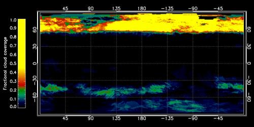
The graphic above unveils the percentage of cloud coverage on the globe of Titan in a period ranging from July 2004 to April 2010. The yellow color indicates the highest level of cloud coverage as shown by the color scale. Latitude and longitude coordinates are incorporated along the margins of the graph to identify the geographic positions of the cloud systems. It turns out that the highest concentration of clouds was found in the high latitudes of the northern hemisphere during the period studied. Some dynamic and dissipating clouds have been regularly observed in the south polar region, as well and transient, elongated clouds sometimes appeared in the mid-latitudes of the southern hemisphere. Image credit: NASA/JPL/University of Arizona/University of Nantes/University of Paris Diderot.
- To get more information on that news, go to: http://saturn.jpl.nasa.gov/news/cassinifeatures/feature20100921 and http://www.gps.caltech.edu/~oa/titanlakes.shtml.
August 23, 2010: Radar Data Reveal Tall Mountains And Suggest Contractional Tectonics on Titan
The radar mapper of the Cassini Spacecraft has revealed complex topographic features on Titan since its arrival in the Saturn System in 2004. The radar instrument which sees through the deep and opaque gas blanket surrounding the moon unveiled a remarkable variety of landscape features such as dune fields, lakes, drainage channels, canyons, wrinkled terrains, hills and mountains, impact craters and, perhaps, calderas or cryovolcanic domes.
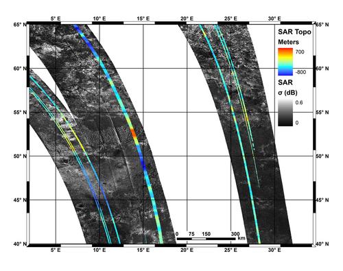
Some radar data reveal captivating features related to tectonics: an irregular terrain made of hills or mountains with peaks as tall as about 1,400 meters relative to the level of the surrounding valley can be found near 52 degrees north latitude and 13 degrees east longitude, in the north of Aaru. Likewise, at least three parallel mountain chains can be observed on the northwest border of Xanadu, at two degrees south latitude and minus 127 degrees west longitude. The highest features are approximately 1,900 meters (about 6,232 feet) taller than the surrounding plains. Another radar portion unveils parallel mountain chains near Adiri at about 10 degrees south latitude and 145 degrees east longitude, with altitude differences between plains and hills of about 700 meters or 2,300 feet.
The mountain formations, in the three regions mentioned above, are reminiscent of geological phenomena observed on our planet. It seems that the outer crust of Saturn's largest moon is quite unstable and that tectonics is dominated by contractional processes rather than extensional processes.
A model focusing on mountains and tectonics on the Orange Moon and showing that differing densities in the outer shells of the globe can explain the unusual surface processes is presented in the Journal of Geophysical Research on June 25, 2010 by Guiseppe Mitri, M.T. Bland, A.P. Showman, J. Radebaugh, B. Stiles, R.M.C. Lopes, J.I. Lunine, and R.T. Pappalardo. The paper is entitled "Mountains on Titan: Modeling and Observations".
The authors explain that the icy moon has been cooling since its formation about 4 billion years ago. The smoggy moon is, in fact, releasing heat and radioactive isotopes which are decaying in the interior, since the origin. The cooling process is very slow but the Orange Moon is progressively losing its energy. This cooling process causes parts of the presumed subsurface ocean to freeze over. As a result, the outermost ice crust thickens and the surface tends to ripple. Titan is shrinking, to a certain extent and the surface crumples, appears wrinkled like a raisin.
Guiseppe Mitri, the lead author of the work and a Cassini radar associate based at the California Institute of Technology in Pasadena pointed out: "Titan is the only icy body we know of in the solar system that behaves like this."..."But it gives us insight into how our solar system came to be."
Some scientists didn't expect to find mountains as high as the highest peaks found on Titan. Some mountains can be as tall as the highest summits in the Appalachian Mountains. The material of the crust was not believed to be strong enough to support the weight of a sharp mountain.
Mountains on Titan were first observed in 2005 via radar images. It appears that several mountain chains, generally oriented west-east, take shape in the equatorial area. Therefore, contractional phenomena seem to dominate in that area. Similar phenomena can be found on the Earth: one can mention the Zagros Mountains in Iran which were generated by the collision of the Arabian and Eurasian plates which are two continental tectonic plates. The surface crumples due to contractional phenomena.
Titan appears to be the only icy moon where contractional tectonics is dominant. In most icy moons, the mountains or elevated terrains are engendered by a stretching process of the ice shell or by other geological processes. Contractional tectonics which seems dominant on the Orange Moon corresponds to forces shortening and thickening the outer ice layer whereas extensional tectonics corresponds to forces stretching the outer ice layer.
Giuseppe Mitri and his collaborators incorporated radar data into computer models to account for tectonics on Titan and to analyse the interior structure and its evolution. They postulated that the internal structure of the satellite was only partially separated into a mixture of rock and ice. That assumption is consistent with data from Cassini's radio science team. They modified the parameters in order to account for the mountains observed on Titan.
It appears that the structure of the moon consistent with the observations is made of a very dense layer of high-pressure water ice on which appears a subsurface liquid-water-and-ammonia ocean. The outermost water-ice layer appears above the subsurface ocean which apparently plays a key role in the way mountains emerge. The temperature increases as you go deeper inside the moon and the temperature in the upper layer averages approximately 94 Kelvin, minus 290 degrees Fahrenheit or minus 179 degrees Celsius.
The density increases as you go down inside the moon. The cooling process in the moon leads to a partial freezing of the subsurface liquid ocean and a thickening of the outer water ice layer. The high-pressure ice is also thickened. The interior layers lose volume and the crust folds or crumples. Saturn's largest moon has lost a lot of energy since its formation and it is still expelling hundreds of gigawatts of power which may be enough to generate crustal movements. The model of Giuseppe Mitri and his collaborators predicts a shortening of the radius of Titan by approximately seven kilometers or four miles and a drop in volume of about one percent.
Jonathan Lunine, a scientist based at the University of Rome, Tor Vergata in Italy and co-author of the work advanced: "These results suggest that Titan's geological history has been different from that of its Jovian cousins, thanks, perhaps, to an interior ocean of water and ammonia." He concluded: "As Cassini continues to map Titan, we will learn more about the extent and height of mountains across its diverse surface."
Moreover, the energy source rising from the interior of Titan is not the only factor which can account for the formation of the mountainous areas. Winds can sculpt the landscape and form geological structures such as Seif Dunes. Meteorites can engender strong deformation processes of the icy crust and generate high topographic rims in the impact crater.
Prevailing winds in the tropics or in the equatorial area appear to have a strong topographic influence on the basis of the long, parallel dune fields or Seif Dunes, mostly oriented West to East. One can find dunes approximately a kilometer or half a mile wide and tens to hundreds of kilometers or miles long. The dunes can be as high as 100 meters or 300 feet. The dunes appear to be mostly composed of organics or hydrocarbon particles. Their ridges are generally oriented west-to-east, parallel to the equator.
Fundamentally, scientists had predicted that surface winds generally blow from the east to the west around Titan's equatorial belt. However, the first images of dunes in 2005 suggested that prevailing winds were blowing from the opposite direction, or west to east. That's a paradox that Tetsuya Tokano may have understood. Tetsuya Tokano presents his work on the paradox in the journal Aeolian Research.
Why is it a paradox? Because at higher latitudes, the prevailing winds blow west-to-east. As a result, we deduced that winds in the low latitudes around Titan's equator would run east-to-west. Tetsuya Tokano claims that seasonal changes appear to reverse wind patterns on Saturn's largest moon for a short period. The transient phenomenon which may last about two years sculpts the dunes with winds blowing, strongly, from the west to the east. The east-to-west surface winds may be weaker and have a weak influence on the modifications in the topography of the dunes.
Tetsuya Tokano, of the University of Cologne, Germany pointed out: "It was hard to believe that there would be permanent west-to-east winds, as suggested by the dune appearance." He added: "The dramatic, monsoon-type wind reversal around equinox turns out to be the key."
Tetsuya Tokano focused on variations in the wind at different points in time rather than the averages and it appears that Equinox periods may be the reversal period of winds. During equinox, the solar radiation penetrates over the equator generating an extra heat which engenders an upwelling in the atmosphere. The very dynamic mixing causes the winds to reverse and accelerate. These episodic winds turn out to blow approximately 1 to 1.8 meters per second (2 to 4 mph). And the sand may start to move when the wind speed is about 1 meter per second or 2 mph, a speed that the usual east-to-west winds never appear to exceed. The short wind episodes can be encountered on the Earth in the northern Namib sand seas in Namibia, Africa.
Titan's topography is mainly influenced by its internal activity and tectonics. Winds and meteorites also influence the landscape. The appearance of the surface may also be painted by the icy, organic or oxygen-bearing particles evolving in the Saturn system as it is the case on Iapetus or Enceladus.
The mosaic above using radar portions unveils mountains or elevated terrain near Adiri. The colors show the elevation level. The red areas reveal the highest peaks and the purple areas show the lowest elevation. Image Credit: NASA/JPL-Caltech
The radar mosaic above unveils parallel mountain chains apparently related to contractional tectonics. The mountains appear on the northwest border of Xanadu. The tallest landscape features are about 1,900 meters (or 6,232 feet) higher than the surrounding plains. Image Credit: NASA/JPL-Caltech
The mosaic above made of radar images shows mountains in the north of Aaru. The colors are incorporated into the radar mosaic to indicate altitude levels. The red-orange areas correspond to the highest elevation level. The purple areas correspond to the lowest elevation level. The tallest peaks appear approximately 1,400 meters ( or 4,592 feet) higher than the surrounding valley. Image Credit: NASA/JPL-Caltech
The mosaic above reveals the similarities between the Namibian sand dunes and the linear and parallel dunes of the low latitudes of Titan observed with the radar mapper. The upper part of the view corresponds to a radar portion of Titan which unveils the enigmatic Seif Dunes. The lower portion of the mosaic shows the Namibian sand dunes. Image credit: NASA/JPL (upper view), NASA/JSC: (lower view)

The artistic view above reveals typical Seif dunes which may be encountered in the Tropics on the Orange Moon, Titan. The computer-generated view is based on Google Earth data of the Namibian sand dunes. One can notice that the linear and parallel structures observed from high altitudes show an irregular topography when they are viewed from a relatively low altitude.The winds exert a complex action on the formation of the dunes. The dunes fields of Titan may be particularly inhospitable for a future human colony. The dunes are likely made up of organics and hydrocarbons such as benzene. It may be particularly hard and dangerous to walk on that kind of dune due to its instability and low density. Therefore, the sands may act as quicksand capable of gobbling any explorer walking with a normal spacesuit. © Artistic Image: Marc Lafferre, 2010
- To get more information on that news, go to: http://saturn.jpl.nasa.gov/news/cassinifeatures/feature20100812, http://saturn.jpl.nasa.gov/news/cassinifeatures/feature20100729 and http://www.astrobio.net/pressrelease/3546/oxygen-moves-from-enceladus-to-titan.
July 21, 2010: Ontario Lacus Unveiled by Radar Data: A Study Shows the Lake has Shrunk
A radar image of Ontario Lacus, the first pool of liquids identified on Titan, reveals captivating features reminiscent of Terrestrial lakes or seas. Ontario Lacus is located in the southern hemisphere of Saturn's largest moon and is centered at about 72 degrees south latitude, 183 degrees west longitude.
Ontario Lacus appears to be the largest pool of liquids in the south polar region. The lake is 235 km long and has a surface area of approximately 15,000 square kilometers or 6,000 square miles which is slightly smaller than Lake Ontario in North America.
The kidney-shaped lake was first observed in 2004 with the imaging camera of the Cassini spacecraft. Ontario Lacus appears uniformly dark in the infrared or near-infrared images which implies a smooth, absorbing surface.
Ontario Lacus is likely composed of a mixture of methane, ethane and propane, three compounds which can be found in their liquid form in the harsh environment of the Opaque Moon. In the south polar area, surface temperatures can be as low as 90 Kelvin, -300 degrees Fahrenheit or -183 degrees Celsius.
The atmospheric pressure at the surface is higher than that of the Terrestrial atmosphere at sea level. Under those circumstances, no liquid water is expected on the ground unless there is a strong geothermal source or a volcanic activity. Water may appear as hard as our rocks or pebbles on the surface of Titan.
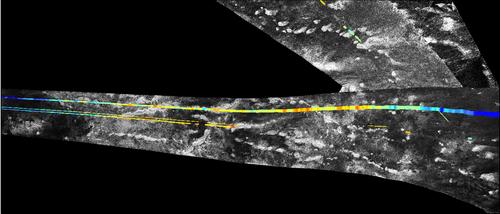
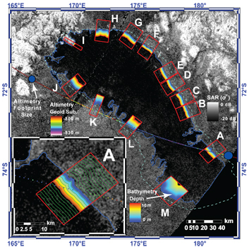
The radar view of Ontario Lacus obtained by the radar mapper of the Cassini probe on January 12, 2010 clearly shows the irregular shoreline and the depth variations. One can notice the first well-developed delta observed on the Orange Moon, on the western shore of the giant lake.
A meandering drainage channel fuels the bay in which the delta is found. The shape of the land implies that the liquid is flowing down from a higher plain. The two topographic lobes may result from the action of the river.
Steve Wall, deputy team leader for the Cassini radar team, based at NASA's Jet Propulsion Laboratory in Pasadena, California pointed out that this sort of channel switching and wave-modified deltas can be observed on our planet at the southern end of Lake Albert between Uganda and the Democratic Republic of Congo in Africa.
The darkness intensity of the radar data in the lake provides information on the depth of the liquid along the shoreline. A higher albedo implies that the depth of the liquid area is lower. Thus, the northwestern rim of Ontario Lacus seems to be made of a smooth beach and shallow liquids.
Low waves could engender smooth lines parallel to the current shoreline over time. The waves are likely generated by winds blowing from the west or southwest. The waves erode and sculpt the shoreline like the waves along the Terrestrial coasts.
One may find striking similarities between the shoreline sculpted by waves of Ontario Lacus and that of the southeastern side of Lake Michigan where waves exert a strong action on the shoreline. The eastern rim of Ontario Lacus appears sharp and the liquid along the shoreline appears to be deeper than in the western part. Scientists used radar data from Cassini's Titan flybys on June 22, 2009, July 8, 2009 and January 12, 2010 to generate a video tour of Ontario Lacus.
Steve Wall argued: "With such frigid temperatures and meager sunlight, you wouldn't think Titan has a lot in common with our own Earth."..."But Titan continues to surprise us with activity and seasonal processes that look marvelously, eerily familiar."
A recent study reveals that Ontario Lacus and other lakes in the southern hemisphere have shrunk with a decrease in the lake level. The analyses on the lake level, the bathymetry and the nature of the liquid are presented in the following two papers: "Transient Surface Liquid in Titan's Polar Regions from Cassini" submitted to Icarus and "Bathymetry and Absorptivity of Titan's Ontario Lacus" accepted by JGR.
Alexander G. Hayes, a graduate student of the California Institute of Technology (Caltech), Oded Aharonson, associate professor of planetary science at Caltech and their collaborators have determined that the shoreline of Ontario Lacus receded by approximately 10 kilometers (6 miles) from June 2005 to July 2009.
The southern hemisphere of the Opaque Moon was experiencing the summer period when the Cassini spacecraft arrived at Saturn in 2004. The autumn equinox occured in August 2009. One season is very long on Titan: it lasts 7 Terrestrial years and one Titan year lasts 29.5 Earth years.
It seems that during the summer period, the evaporation process of liquid methane has been particularly strong. The data suggest that the levels of lakes in the southern hemisphere decreased by about 1 meter per year or 3 feet per year over a four-year period. The drop is, a fortiori, related to the seasonal evaporation of simple hydrocarbons or methane.
Alexander Hayes pointed out: "We are very excited about these results, because we did not expect Cassini to be able to detect changes of this magnitude in Titan's lakes."..."It is only through the continued monitoring of seasonal variation during Cassini's extended mission that these discoveries have been made possible."
Moreover, one can wonder whether a portion of liquid methane penetrates or infiltrates into a porous ground. However, the presence of large cloud formations in the south polar region suggests strong evaporation processes from the bodies of liquids.
There may be a methane cycle on Titan, intimately linked to seasonal factors, involving evaporation and precipitation processes. According to Alexander Hayes, the south polar lakes may grow again during southern winter. The next winter solstice of the southern hemisphere will occur in 2017.
Synthetic Aperture Radar and altimetry data of Ontario Lacus were obtained. Dr. Oded Aharonson explained: "The combination of SAR and altimetry measurements across the transect gave information about the absorptive properties of the liquid, and argues that the liquids are relatively pure hydrocarbons made up of methane and ethane and not a gunky tar."
Alexander Hayes advanced that the liquid of the lake is not highly attenuating. In other words, the liquid is relatively transparent, like liquid natural gas. As a result, the radar signal can penetrate into the liquid to a depth of several meters and return to the spacecraft. If the pool of liquids is deeper than a few meters, the radar signal may be completely absorbed generating a black signature. Changes or variations in radar signals enable scientists to infer the depths, the slope along the shoreline or the bathymetry.
Alexander Hayes pointed out: "We were able to determine the bathymetry of the lake out to a depth of about 8 meters." The pool appears to be shallowest along its southern edge, due to sediment accumulations. By contrast, the northern shoreline hosts steep slopes. The shoreline in that area is close to a range of mountains.
Alexander Hayes explained: "The extent to which the lake has receded is related to the slope -i.e., where the lake is shallow, the liquid will have receded more."..."This allows us to deduce the vertical height by which the lake depth has dropped, which is about 1 meter per year." A similar result was obtained for the small lakes of the area imaged in December 2007 and May 2009, whose level decreased or disappeared completely.
Besides, one of the most astonishing geological features along the shoreline of Ontario Lacus is probably the irregular bay in the southeastern part of the lake. The liquid in the bay appears particularly deep and a deep topographic incision of the linear shoreline can be clearly spotted. The presence of the two topographic lobes may be explained by ancient or present drainage channels. The bay may have been formed by an impact crater, as well. Let's dream: this irregular bay may become a natural harbour for a future exploration boat.
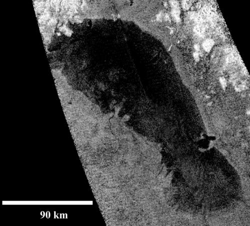
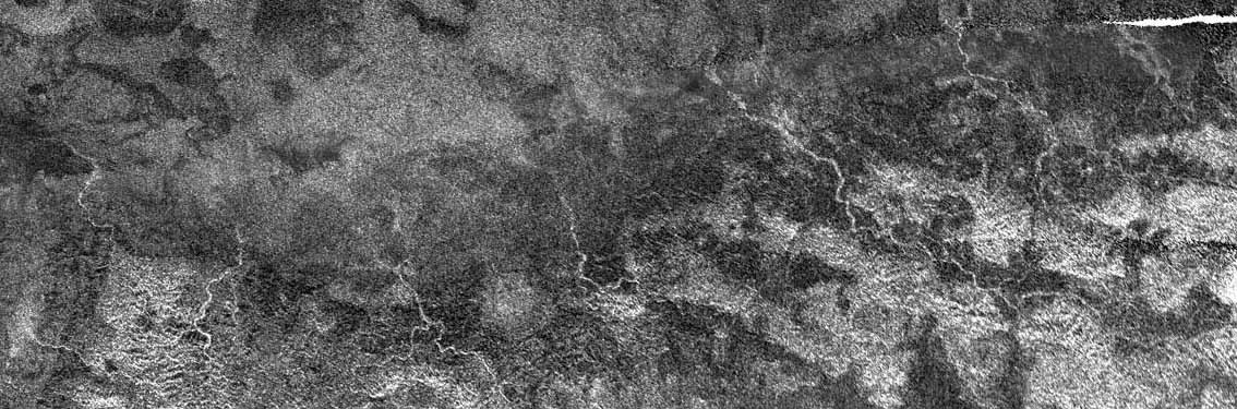
The radar image above shows Ontario Lacus. The view was acquired on January 12, 2010 by the the radar mapper of the Cassini spacecraft. A sinuous drainage channel can be clearly identified in the western shoreline of the lake. The two topographic lobes, in that area, may result from the fluvial activity. A surprising bay revealing an apparently deep depression can be noted along the eastern rim of the lake. The northern coastline unveils flooded river valleys as well as hills about 1 kilometer or 3000 feet in altitude. Image credit: NASA/JPL-Caltech.
The composite view above shows a Synthetic Aperture Radar or SAR map of Ontario Lacus. The outlines of June 2005 and June/July 2009 of the pool are shown in cyan and blue. As a result, it appears that the lake receded during that period. Image credit: Radar Science Team, NASA/JPL/Caltech.
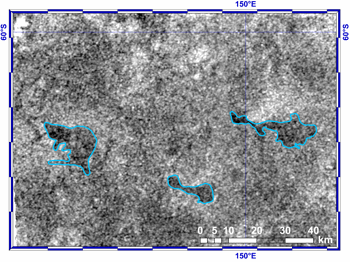
The radar image above shows ephemeral lakes located in the south polar region. The observations show that the lakes outlined in cyan appear partially filled. The views taken in December 2007 (T39 flyby) and May 2009 (T55 flyby) reveal that the lakes dried up during that period. Image credit: Cassini Radar Science Team, NASA/ JPL/Caltech.
 |
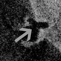 |
The artistic image in the upper part of the table above shows a weird bay of Ontario Lacus along its eastern shoreline. It seems that the lake depth is relatively high in that area because the radar image, shown in the lower part of the table above, shows a particularly dark and uniform portion. This intriguing bay may have been engendered by a meteoritic impact generating a topographic depression within the lake. This bay may also correspond to a volcanic caldera. The hypothesis involving the action of a fluvial activity in the formation of this enigmatic landscape feature is considered, as well. The gray arrow indicates the direction of the virtual camera in the computer-generated view presented in the upper part of the table. © Artistic Image: Marc Lafferre, 2010; Radar Image Source: NASA/JPL.
- To get more information on that news, go to: http://saturn.jpl.nasa.gov/news/cassinifeatures/feature20100715 and http://media.caltech.edu/press_releases/13354.
June 19, 2010: A Flux of Hydrogen to the Surface of Titan and a Lack of Acetylene on the Ground Raise the Hypothesis of a Methane-Based Life
The discovery of large pools of liquids and rivers, mostly composed of ethane and methane, in the high latitudes of Saturn's largest moon Titan, from radar images obtained with the radar mapper of the Cassini spacecraft, pushes scientists into advancing the hypothesis of a methane-based life.
New findings strengthen the hypothesis for the development of a primitive form of life based on methane in the harsh environment of Titan's surface. The first discovery is related to atmospheric flows of molecular hydrogen, downward, to the surface of the Orange Moon.
This finding is presented by Darrell Strobel, in a paper entitled "Molecular hydrogen in Titan's atmosphere: Implications of the measured tropospheric and thermospheric mole fractions". The paper appears in the Journal Icarus and is available online since March 2010.
The second discovery is related to a lack of acetylene (ethyne, C2H2) on the surface of Titan. The study which leads scientists to this finding is performed by Roger Clark, a Cassini team scientist based at the U.S.Geological Survey in Denver. The finding is presented in the Journal of Geophysical Research in 2010 in a paper entitled "Detection and Mapping of Hydrocarbon Deposits on Titan".
The hydrocarbon mapping research which reveals a lack of acetylene on the ground is based on data from the Visual and Infrared Mapping Spectrometer of the Cassini probe.
The two findings involving acetylene and hydrogen are consistent with the scenario of a biological cycle based on methane, acetylene and hydrogen. The study led by Darrell Strobel and his collaborators shows that a portion of molecular hydrogen in the Titanian atmosphere goes downward into the surface and disappears.
The disappearance of hydrogen at the level of the soil implies that a substance or a catalyst is absorbing and transforming this flux of molecular hydrogen. The presence of a methane-based life may account for that phenomenon. An exotic form of life based on methane would absorb hydrogen molecules and expire methane resulting from the chemical reactions involving hydrogen and carbon-made molecules inside the living organism.
The hypothesis of that kind of chemical reaction is strengthened by the research showing a lack of acetylene on the ground. Acetylene may be consumed as food by living organisms. Acetylene and hydrogen may react in the exotic lifeform to produce methane. The reaction produced by the methanogens is summarized by the following equation: C2H2 + 3H2 =>2 CH4.
Darrell Strobel who is a Cassini interdisciplinary scientist based at Johns Hopkins University in Baltimore, Maryland examined the upper atmospheres of Saturn and Titan and analyzed data from the Composite Infrared Spectrometer and the Ion and Neutral Mass Spectrometer of the Cassini spacecraft. The research describes densities of hydrogen in different parts of the atmospheric blanket and the surface.
Hydrogen molecules were expected to be distributed fairly evenly in the deep and opaque atmosphere of Titan on the basis of previous models. However, the study reveals a disparity in the hydrogen densities that implies a flow down to the ground at a rate of approximately 10,000 trillion trillion hydrogen molecules per second. This represents about the same rate at which the molecules escape out of the upper atmosphere.
The ultraviolet light from the Sun plays a key role in forming hydrogen molecules: in the upper atmosphere, the UV radiations break apart acetylene and methane molecules generating radicals or new molecules including molecular hydrogen.
Darrell Strobel was clearly surprised by the disappearance of hydrogen on the ground. He explained: "It's as if you have a hose and you're squirting hydrogen onto the ground, but it's disappearing."..."I didn't expect this result, because molecular hydrogen is extremely chemically inert in the atmosphere, very light and buoyant. It should float to the top of the atmosphere and escape."
The flux of hydrogen into the soil is inferred from a computer simulation developed to account for the measurements of the hydrogen concentration in the lower and upper atmosphere. Thus, the determination of this flux is not the outcome of a direct observation. Does the computer simulation correctly replicate this process of the atmospheric chemistry?
Chris McKay, an astrobiologist at NASA Ames Research Center, Moffett Field, California, who imagined the key ingredients for the development of a methane-based life on Titan in 2005 notes that acetylene appears to be the best energy source for a lifeform based on methane. The lack of acetylene on the ground suggests its potential absorption by a mineral, a catalyst or an exotic creature.
Chris McKay and Heather Smith had postulated that the hypothetical methanogens of the Orange Moon could consume hydrogen, acetylene and ethane. The new findings strengthen their scenario.
The surprising flux of hydrogen downward turns their biological cycle into a relevant model. Chris McKay pointed out: "We suggested hydrogen consumption because it's the obvious gas for life to consume on Titan, similar to the way we consume oxygen on Earth."..."If these signs do turn out to be a sign of life, it would be doubly exciting because it would represent a second form of life independent from water-based life on Earth."
The surface image acquired from the Huygens probe on January 14th, 2005 didn't reveal any advanced lifeform or apparent lifeform. However, the radar data of the Cassini orbiter have shown that the wet areas filled with lakes, seas or rivers are concentrated in the high latitudes of Titan and that the tropical area where the Huygens spacecraft landed is, apparently, dry at the present time. If we find life on Titan, it will most likely evolve in the polar lakes, mainly composed of ethane and methane.
There may not be any advanced form of life on Titan but the presence of cryogenic microorganisms or extremophiles based on methane and ethane is not ruled out, even in the Huygens landing site. Heather Smith and Chris McKay wrote in their paper of 2005: "The results of the recent Huygens probe could indicate the presence of such life by anomalous depletions of acetylene and ethane as well as hydrogen at the surface."
The harsh environment of the moon doesn't allow water to appear in its liquid form on the surface. The Huygens probe recorded a surface temperature of -179 degrees Celsius, -290 degrees Fahrenheit or 94 Kelvin. In such a cold environment where the atmospheric pressure on the ground represents, approximately 1467 hPa, one can expect liquid methane, liquid ethane or liquid propane but water will only appear in its solid form on condition that there is no significant energy source coming from the interior (geysers, cryovolcanism, tidal heating).
Prior to the arrival of Huygens and Cassini, photochemical models had predicted an ocean of liquid ethane covering the entire globe to a thickness of many meters. It turns out that the hypothetical ocean doesn't exist. The presence of large amounts of ethane and methane raises, however, the possibility of a methane-based life.
The extremophile may thrive in a liquid solvent made of carbon and hydrogen such as liquid methane and liquid ethane, instead of liquid water. The exotic lifeform would eat organics, present on the ground in large quantities. Let's note, however, that no acetylene was detected in the gases released from the soil after the Huygens spacecraft touchdown (Niemann et al.2005, Lorenz et al.2006).
The properties of hydrocarbon solvents for the development of any lifeform were put forward as soon as 2004 by Benner et al. The researchers said: "... in many senses, hydrocarbon solvents are better than water for managing complex organic chemical reactivity."
Attempts to compute the energy available for methanogenic life on the basis of organics, acetylene, methane, ethane and hydrogen were presented in 2005 in two papers, by McKay and Smith and Schulze-Makuch and Grinspoon. In both papers, H2 plays the same biological role on Titan as O2 does in the biological system of the Earth. The living organisms would absorb H2 and release CH4.
In the paper of D.Schulze-Makuch and D.H.Grinspoon entitled "Biologically enhanced energy and carbon cycling on Titan?", acetylene represents a key ingredient of the food for the living organisms, providing a large amount of energy.
McKay and Smith noted that if there is life living in liquid methane, the form of life should be widespread on Titan simply because liquid methane is widespread on the ground. The Huygens probe showed that the landing site was moist with methane.
The lack of acetylene on the ground contradicts the models suggesting that the acetylene produced in the upper atmosphere of Titan via photolysis and the action of ultraviolet light falls down to coat the icy soil. Are there microorganisms in the air and on the ground which absorb the acetylene? That's what the finding of Roger Clark suggests.
Moreover, the spectrometer of the Cassini spacecraft didn't identify water ice on the surface. That's quite surprising. Large amounts of benzene (C6H6) and another material, not yet identified, were detected. As result, it seems that water ice is permanently covered by a film of hydrocarbons at least a few millimeters to centimeters thick. The thickness of this film may even be greater in some places.
Roger Clark argued: "Titan's atmospheric chemistry is cranking out organic compounds that rain down on the surface so fast that even as streams of liquid methane and ethane at the surface wash the organics off, the ice gets quickly covered again."..."All that implies Titan is a dynamic place where organic chemistry is happening now."
The lack of acetylene on the surface is likely to have non-biological explanations, as well, as Mark Allen, principal investigator with the NASA Astrobiology Institute Titan Team, based at NASA's Jet Propulsion Laboratory in Pasadena, California advanced. The solar and cosmic radiations may transform the acetylene of the upper atmosphere into more complex molecules falling to the soil.
Mark Allen pointed out: "Scientific conservatism suggests that a biological explanation should be the last choice after all non-biological explanations are addressed."...."We have a lot of work to do to rule out possible non-biological explanations. It is more likely that a chemical process, without biology, can explain these results, for example, reactions involving mineral catalysts."
Marc Lafferre, a specialist of Titan, emphasizes the potential for a biological cycle based on liquid ethane, methane, hydrogen and organics. One can envisage an ecosystem with exotic animals drinking ethane, eating organics, plants or other animals, breathing in molecular hydrogen and breathing out methane. In that ecosystem, some exotic plants would absorb organics and liquid ethane, breathe in methane and breathe out molecular hydrogen, hence sustaining the cycle of methane and hydrogen in the harsh environment of Titan.
 |
 |
The artistic image, in the upper part of the set of images, represents a bay of Mayda Insula, a big island located in the northern part of the north polar sea Kraken Mare. The middle image represents a radar view of the island inside Kraken Mare. Kraken Mare appears uniformly dark in the radar image. The bottom image represents a zoom on the bay represented by the computer-generated image. The grey arrow, incorporated into the radar view acquired by the radar mapper of the Cassini spacecraft, indicates the field of view of the virtual camera in the computer-generated view. Does Kraken Mare harbour an exotic lifeform based on methane? © Artistic image: Marc Lafferre, 2010; Radar image source: NASA/JPL.
- To get more information on that news, go to: http://saturn.jpl.nasa.gov/news/newsreleases/newsrelease20100603 and http://www.spacedaily.com/reports/Have_We_Discovered_Evidence_For_Life_On_Titan_999.html.
June 5, 2010: Reflective Pebbles May Account For the Remarkable Brightness of Channels in the Southwest of Xanadu
The in-depth study of Titan's surface on the basis of data acquired from the Cassini spacecraft and the Huygens probe reveals that Saturn's largest moon is a complex world with mountains, dunes, lakes, seas and rivers.
The radar data have revealed dark patches in the north polar regions and the south polar regions. These dark, uniform patches appear to be lakes or seas. These bodies of liquids are often connected to dark drainage channels.
The radar mapper reveals two kinds of channels, high-albedo channels or highly-reflective channels and dark channels. The dark channels are likely filled with liquid methane and liquid ethane and the bright channels probably represent dried-up rivers.
A study on the radar bright channels in the southwest of Xanadu has been recently performed by a group of scientists led by Alice Le Gall, a postdoctoral fellow at NASA's Jet Propulsion Laboratory, Pasadena, California. The analysis is presented in a paper in the Journal Icarus (Volume 207, Issue 2, June 2010). The paper is entitled "Radar-bright channels on Titan".
Alice Le Gall, M.A. Janssen, P. Paillou, R.D. Lorenz, S.D. Wall and their collaborators focus their attention on the radar strip of the T44 flyby of the Orange Moon, acquired on May 28, 2008 with the Cassini SAR or Synthetic Aperture Radar.
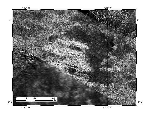
This radar portion covers an intriguing area in the southwest of the optically-bright region of Xanadu where sinuous, bright channels clearly appear in the lowlands of Xanadu. It seems that flash flooding transporting icy materials has occured in the area. Several bright, sinuous channels originating in the radar-bright highlands of Xanadu can be clearly spotted. The area is found between 130 degrees west longitude and 150 degrees west longitude in the equatorial area.
The highly reflective channels are probably dry. They are most likely riverbeds containing debris or pebbles shaped by the fluid of the stream. Alice Le Gall advanced:" What we believe happened in this area is a lot like what creates polished river rocks on Earth."..."Bouncing downstream smoothes out the edges of rocks."
The radar signature of the bright, large channels generating high radar returns implies the presence of a relatively high concentration of pebbles, cobblestones or spheres in the riverbeds. Scientists infer that the pebbles or the rocks measure at least a few centimeters or inches and probably up to a couple of meters or yards in diameter. The large radar cross-sections are consistent with the presence of rounded, icy pebbles with a diameter larger than the radar wavelength (2.18 cm).
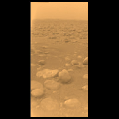
The pebbles photographed by the Huygens probe in its landing site on January 14th, 2005 may give an idea on the erosional processes taking shape in the bright, spidery channels in the lowland of the Southwest of Xanadu. The Huygens spacecraft apparently landed in an ancient riverbed near the equator in the borderland between the bright Adiri and the optically-dark Shangri-La. The pebbles near the probe measured from 2 centimeters or 1 inch to 20 centimeters or 8 inches in diameter.
It seems that the riverbeds in the area where the Huygens probe was parachuted were optically darker than their surroundings. The bright, sinuous channels in the Southwest of Xanadu look brighter than the spot where the Huygens probe landed. As a result, the nature of the rocks or pebbles may be different in the bright streambeds of the Xanadu area.
The stones or pebbles in the meandering channels of Xanadu, which are likely transported by liquids from the high, rugged terrain of Xanadu may have transparency properties. We may see in that area sparkling crystal balls of ice. Alice Le Gall and her team concluded that the extreme brightness of the channels may be explained by the presence of transparent spherical sediments whose distribution is more concentrated than at the Huygens landing site.
The rounded sediments or pebbles in this area of Xanadu may be composed of water ice mixed with ammonia. In the harsh environment of Titan, the icy stones or pebbles may be as hard as mineral rocks on our planet. Water appears in its solid form on the surface of Titan where the temperature is about -179 degrees Celsius, -290 degrees Fahrenheit or 94 Kelvin and the atmospheric pressure is approximately 1467 hPa. The reflective material may well explain the microwave return generated by the radar mapper.
It seems that the streams in Xanadu have transported chunks, boulders, debris, stones or pebbles over long distances, for hundreds of kilometers or miles from the elevated terrain in Xanadu to the lowland or basin. The southward slope appears relatively gentle. Scientists suggest that the icy spheres transported by the liquids probably traveled around 1 meter per second or 2 mph.
A surprising variety of gems may be found in that area thanks to the action of fluids such as liquid methane or ethane, rain falls or winds. Grits or gravels may play a key role, as well, in shaping the rocks or the pebbles in the stream of hydrocarbons.
The origin of the fluid which accounts for the bright channels is unclear but scientists believe that the rivers took shape relatively suddenly. The fluids may appear periodically over time.
Are the fluids of Xanadu related to rainfalls of hydrocarbons? Are they linked to an internal activity, geysers or cryovolcanoes? Or are they linked to a meteoritic impact which would have triggered a flash flooding of molten material resulting from the energy of the impact?
The behaviour of water ice, ammonia ice or frozen carbon dioxide , in the harsh environment of the Orange Moon with very low temperatures is not perfectly understood. Will the ice undergo fractures during the collisions inside the fluid or will it deform plastically? In other words, is the icy material malleable in Titan's cold temperatures? More study or simulations should be performed on the mechanical properties of water ice in the exotic conditions of this enigmatic moon.
Steve Wall, a radar team member at JPL pointed out: "It's been really hard for a long time for people to understand why Xanadu is so bright." He concluded: "You might not expect these kinds of geometries in a natural setting, but we believe this can explain the enigma."
Linda Spilker, Cassini project scientist at JPL notes: "Here is yet another example of Titan as a world with Earth-like processes." She argued:" As the seasons change on Titan, maybe we'll get a chance to see methane flow through some of the river channels."
The low latitudes of Titan show very few clouds, in the current period. So, if the streams are related to rainfalls, monsoons or tropical storms don't occur at the moment implying that the area is relatively dry. The wetlands are currently found in the high latitudes of Titan and, notably, in the north polar region.
The bright channels of Xanadu, analysed by the team of Alice Le Gall are reminiscent of the bright channels identified in Hotei Regio and Hotei Arcus. The bright channels in Hotei Arcus are thought to be related to cryovolcanism or related to a meteoritic impact. Should we conclude that the bright channels of Xanadu are related to cryovolcanic events?
The image of Titan above acquired from the Huygens spececraft on January 14, 2005 reveals pebbles and highly eroded rocks suggesting the presence of an ancient gully or river at the landing site. The pebbles in Xanadu are expected to be brighter with transparency properties. Image credits: ESA/NASA/JPL/University of Arizona
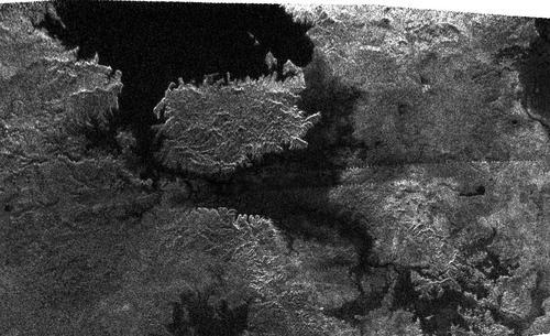
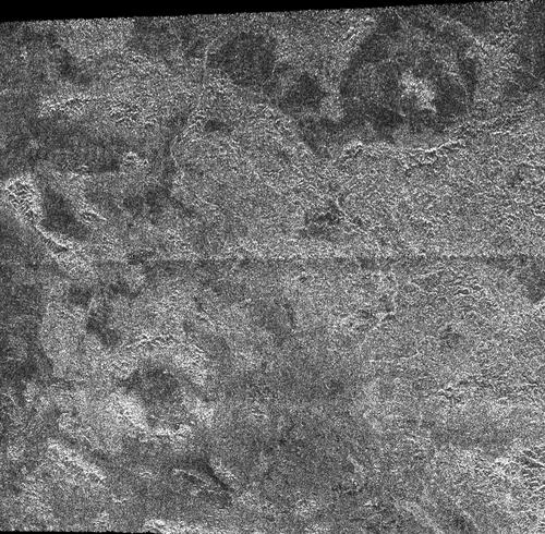
The radar portion of a radar swath, above, obtained by the radar mapper of the Cassini probe on May 28, 2008 shows a region of the bright Xanadu in the equatorial area. It clearly reveals bright channels connected to the bright, irregular terrain. The bright, meandering channels are thought to be ancient drainage channels resulting from rainfalls, cryovolcanism or meteoritic impacts. they might host large amounts of reflective pebbles with transparency properties. Image credit: NASA/JPL-Caltech
The radar portion of a radar swath, above, acquired by the radar mapper of the Cassini spacecraft on February 22, 2008 shows the southern edge of the bright Xanadu in the area called Hotei Arcus. One can clearly identify bright channels roughly orientated into the same direction and connected to a bright area. Similarities can be found between these bright channels and the bright channels analysed by Alice Le Gall and her team. Some scientists suggest that the bright channels might be linked to cryovolcanism or a meteoritic impact. Image credit: NASA/JPL
- To get more information on that news, go to: http://www.jpl.nasa.gov/news/news.cfm?release=2010-156 or http://www.sciencedirect.com (Icarus, Vol 207, Issue 2, June 2010: "Radar-bright channels on Titan").
May 8, 2010: The Finding of a Particular Microbial Life in the Liquid Asphalt of Pitch Lake in Trinidad Raises the Hypothesis of Lifeforms in Hydrocarbon Pools on Titan
Saturn's largest moon, Titan, doesn't appear to be moving in the "Habitable Zone" stricto sensu. The Habitable Zone is commonly defined as the area around the Sun where water can appear in its liquid form on the surface of any planetary body.
Titan evolves well too far from the Sun to harbor lakes or seas of liquid water on its surface. Even if the dense and thick atmosphere of the Orange Moon generates a greenhouse effect, the solar energy received by the soil remains extremely low and the mean surface temperature is around -179 degrees Celsius, -290 degrees Fahrenheit or 94 Kelvin.
If there is water on the surface of the Opaque Moon, it will appear as water ice and it will be closer to our Terrestrial rocks than snowballs. If there is liquid water in this intriguing world, it will likely appear in the deep interior where the internal energy and the tidal forces can potentially turn frozen water into liquid water.
Yet, the exobiological question goes beyond aquacentrism regarding the origin of life. Some lifeforms may emerge from other solvents than liquid water. Titan is an intriguing moon astrobiologically speaking because it harbors bodies of liquid hydrocarbons in its high latitudes or polar regions.
Methane and ethane are thought to be the main constituents of the liquid pools on the surface of the Orange Moon. These compounds are made up of carbon atoms which are key elements of living organisms on our planet.
Therefore, can the hydrocarbon lakes and seas of Titan's wet areas harbor an exotic lifeform? The current state of knowledge doesn't allow us to answer the question. However, a new finding in a natural asphalt lake on Earth fuels the reflection upon the possibility of lifeforms in the bodies of liquid hydrocarbons on Titan.
Some scientists report the finding of particular microbes in the liquid asphalt of Pitch Lake on the Carribbean island of Trinidad. Pitch Lake is the largest natural asphalt lake on Earth representing an area slightly bigger than that covered by Vatican City. Pitch Lake is roughly 40 ha in area and it is reported to be 75 m deep or 246 feet deep.
The other famous asphalt lakes on Earth are La Brea Tar Pits in Los Angeles, the Mc Kittrick Tar Pits in California and Lake Guanoco in the Republic of Venezuela. The liquid asphalt of Pitch Lake may derive from deep faults related to subduction mechanisms and the Barbados Arc under the Carribbean Plate.
The temperature of the liquid asphalt in Pitch Lake ranges from 32 to 56 degrees Celsius or 90 to 132 degrees Fahrenheit. The material is sticky. Steven Hallam, a microbial systems ecologist at the University of British Columbia in Vancouver pointed out: "The tar itself sticks to everything - imagine really smelly molasses".
Bubbles of carbon dioxide and hydrocarbon gases emerge on the surface of the hot asphalt. Each gram of the viscous tar can concentrate up to 10 million microbes. The microbes include bacteria and other single-celled organisms known as archaea.
Some of the archaea or bacteria represent new species. The archaea populations at Pitch Lake turn out to be more varied than those at La Brea Pits in Los Angeles. The environment of Pitch Lake is particular, requiring unusual properties for living organisms in their adaptation process.
The concentration of water in the asphalt is low, at or beneath the evaluated threshold for life on our planet. Some of the bacteria can find pockets of water in that environment in order to thrive. Hence, some bacteria can be found in the harsh conditions of Antarctica in frozen lakes and glaciers in the McMurdo Dry Valleys. But, other types of bacteria can also be found in oxygen-depleted sediments or oil reservoirs.
Even in environments without water, bacteria can adapt and thrive. E. coligut bacteria, for instance, produce most of their own water and fungus identified in kerosene can extract water from light hydrocarbons. The new bacteria found in Pitch Lake show surprising properties: instead of breathing oxygen, they appear to respire by using metals, perhaps iron or manganese.
To a certain extent, Pitch Lake represents a natural laboratory for the relationship between liquid hydrocarbons and living organisms. The "ecosystem" of Pitch Lake shows that liquid hydrocarbons and life are not absolutely incompatible.
The hydrocarbon lakes of Titan are not composed of the same tar and there is no liquid water on the surface. A parallel can be drawn, however and the study of the lifeforms in Pitch Lake is likely to help us better imagine the potential life in the liquid hydrocarbons, in the harsh environment of Titan.
Moreover, some of the methane and ethane lakes of Titan may be engendered by internal sources, providing high amounts of energy from the interior. If the interior is made of liquid water, the conditions for the development of life may not differ so much from those found in the environment of Pitch Lake.
Dirk Schulze-Makuch, an astrobiologist at Washington State University, who is involved in the project, insisted: "An obvious future step is to look at the adaptation mechanisms of these microbes and how they manage to make a living in Pitch Lake, which will give us also some idea of possible adaptation mechanisms for putative extraterrestrial life on Titan."
If we find life on Titan, it will most likely be related to the hydrocarbon solvents and it will show that aquacentrism is not the biological rule for the development of any lifeform. It will also show that life is not the outcome of the most extraordinary chance or coincidence in the history of the Universe. It will also show that lifeforms are probably widespread in the Universe.
Future research will focus on the particular genes the microbes of Pitch Lake incorporate to thrive in the hydrocarbons and metal in this asphalt. It may provide us with new information on the development and the adaptation of lifeforms.
The low temperatures of Titan and the particular chemistry of Titan with lots of hydrocarbons or organics keep us from thinking that any lifeform on the Orange Moon would be similar to that on Earth.
Our life is dominated by DNA and RNA which form out of molecules that require oxygen and phosphorus. One of the main problems is that there's very little oxygen in the environment of the Hazy Moon as Jonathan Lunine, a researcher from the University of Rome Tor Vergata, explains.
" DNA forms a helix because of its water-loving and water-repellant ends." As a result, life on Saturn's largest Moon "would have to find other molecules that carry information." Moreover, the amount of energy available on Titan is very low implying slow chemical processes. That appears to be an inconvenience for building complex biochemical structures.
Jonathan Lunine advanced: "I don't expect you to go to these lakes and see beautiful filamentary structures made of cells that are macroscopic in size or easily seen."
A project aiming at landing a probe on the hydrocarbon sea of Kraken Mare in Titan's high northern latitudes, called Titan Mare Explorer or TiME may provide a clear answer to this big question very soon.
If Titan is geologically active with cryovolcanoes , one can hypothesize eruptions of mixtures of liquid ammonia and water. One can infer, in that scenario, the possibility for living organisms based on water in the deep interior where water molecules are mobile enough or in their liquid form. That hypothesis strongly depends on the amount of energy generated in the interior of Titan and on the material present in the interior of the moon.
Infrared or near-infrared data and radar images tend to show potential candidates for calderas or cryovolcanoes. It appears difficult to discern impact craters and calderas. Between 2004 and December 2007, 22 percent of Titan's surface have been scanned by the Cassini probe and 49 impact craters were spotted.
Among the candidates for cryovolcanoes and impact craters, five topographic features are certain impact craters. The names of these candidates are Ksa, Sinlap, Menrva, Afekan and Selk.
A study classified the craters depending on the degree of certitude regarding the interpretation of their nature. The 44 remaining craters were incorporated into two categories, the category of nearly certain impact craters which corresponds to class 2 and the category of probable impact craters corresponding to Class 3. The best candidates for cryovolcanoes are probably the bright Hotei Regio and Hotei Arcus.
The radar view of the bright Xanadu region, above, reveals, notably, two degraded impact craters. Credit: NASA/JPL
Hence, two completely different lifeforms may exist on Titan today, a lifeform based on liquid water in the deep interior and a lifeform on the surface based on methane and other hydrocarbons.
The image above shows bubbles of hydrocarbon gases and carbon dioxide in Pitch Lake. Image Credit: Pitch Lake Research Group
- To get more information on that news, go to: http://www.astrobio.net/exclusive/3485/asphalt-lake-points-to-possibility-for-life-on-titan-, http://www.astrobio.net/exclusive/3432/life-without-water or http://www.astrobio.net/exclusive/3471/counting-titan's-craters.
March 26, 2010: Analyses based on Cassini Data Suggest a Mixture of Ice and Rock Inside Titan
Saturn's largest moon, Titan, appears to be a complex and captivating world with all the ingredients to fuel the imagination of scientists and amateurs: its deep and opaque atmosphere hides a complex terrain and a landscape shaped, notably, by winds and rainfall. And cryovolcanic or internal activity as well as tectonics may also play a key role in generating landscape features.
There is a consensus among scientists that the interior of the Orange Moon is about half ice and half rock. But how are the materials distributed inside the moon? Are they mixed or are they separated, the heavier materials being beneath the lighter materials?
According to a recent study based on Cassini data, described in the March 12 issue of the journal Science, it appears that the interior of the icy moon is probably not as varied as expected: in other words, the materials may not be completely separated from each other with various layers of different materials. Ice and rock appear to be mixed in the interior with concentrations of each compound varying depending on the depth.
The finding was made possible by precisely tracking the movement and the speed of the Cassini probe as it evolved in the vicinity of Titan. The specialists inferred from the tiny gravitational tugs they measured that the interior has not been warm and dynamic enough to split fully into separate layers of ice and rock.
Bob Pappalardo, a Cassini Project Scientist pointed out:"These results are fundamental to understanding the history of moons of the outer solar system."..."We can now better understand Titan's place among the range of icy satellites in our solar system."
The nature and the distribution of materials inside Saturn's largest moon require precise gravity data. The gravity map was produced by specialists who tracked tiny changes in Cassini's speed along a line of sight from our planet to the spacecraft as it performed four close flybys of the Smoggy Moon between February 2006 and July 2008. The Cassini probe took paths between approximately 1,300 to 1,900 kilometers (800 to 1,200 miles) above Titan.
Luciano Less, a Cassini radio science team member at Sapienza University of Rome in Italy, and the paper's lead author pointed out:"The ripples of Titan's gravity gently push and pull Cassini along its orbit as it passes by the moon and all these changes were accurately recorded by the ground antennas of the Deep Space Network within 5 thousandths of a millimeter per second (0.2 thousandths of an inch per second) even as the spacecraft was over a billion kilometers (more than 600 million miles) away."..."It was a tricky experiment."
Inspite of the significant gravitational influence of Saturn and the other moons or inspite of the gravitational tides, it seems that the interior of Titan is not warm and dynamic enough to be differentiated into separate layers of ice and rock. In Titan's long history, the rocks probably never heated up beyond a relatively lukewarm temperature. The rocks may not be present, however, in the crust of Titan. It seems that Titan's ice is devoid of any rock in the outermost 500 kilometers (300 miles) of the moon.
David J. Stevenson, one of the paper's co-authors and a professor of planetary science at the California Institute of Technology in Pasadena explained:"To avoid separating the ice and the rock, you must avoid heating the ice too much."..."He concluded:"This means that Titan was built rather slowly for a moon, in perhaps around a million years or so, back soon after the formation of the solar system."
If one had to classify Titan in a category based on its internal structure and the differentiation criterion, it would probably appear in the same category as Jupiter's moon Callisto. The Jovian moon, Callisto is thought to host a mixture of ice and rock in its deep interior. On the other hand, Jupiter's largest moon, Ganymede, is believed to be a differentiated body where ice and rock have completely separated.
So, the size of any planetary body is not a determining factor for the distribution of materials inside the body. The history of the moon or planet as well as the way it was formed play a key role in forming the geologic layers. Regarding the internal structure, it turns out that Titan is more like Callisto than Ganymede.
The mean density of Titan, close to 1.88 g/cm3, is relatively low compared to that of Mercury, Venus, the Earth or Mars but it remains higher than that of Saturn or the other icy bodies orbiting the ringed planet. Since there is no clear differentiation in its interior , it seems that the density doesn't increase significantly with depth. And the core of the moon may be simply made of rock.
The infrared or near-infrared views of Titan's topography as well as the radar portions captured from the Cassini spacecraft suggest a landscape undergoing the action of meteorology, with winds and methane or ethane rain generating rivers, lakes or seas. It appears quite difficult to distinguish between topographic features carved by flows related to meteorology and topographic features related to a potential cryovolcanic activity.
Titan's landscape exhibits a multitude of dark or bright channels or dark circular features which may be interpreted as impact craters or calderas or cryovolcanoes. It seems that the highest mountains on Titan are relatively low in altitude, probably because of the nature of their compounds which are not strong enough to sustain the weight of a tall mountain.
The finding regarding the internal structure of Titan doesn't seem to be consistent with the hypothesis for an underground ocean. Marc Lafferre, a specialist of Titan, notes that a subsurface ocean made up of liquid hydrocarbons such as methane, ethane and propane appears more likely than a subsurface ocean made of liquid nitrogen, ammonia or water. This assumption is mainly based on the fact that the temperature in Titan's environment seems too low to allow water, carbon dioxide or ammonia to appear in their liquid state.
The nature of the subsurface ocean may be intimately linked to the internal energy or the temperature beneath the crust. And this energy may come from hot spots, cryovolcanic sources or tidal phenomena associated with the gravitational influence of Saturn and the other moons. The detection of the potential tides is a major goal of the radio science team because it would have strong implications regarding the possibility of a hidden water layer.
Scientists claim that the methane present in the atmosphere may have an internal origin. An internal source may replenish the atmosphere with methane because the "life expectancy" of a methane molecule is limited (a few million years) and the UV light tends to break down methane molecules. Marc Lafferre notes that the recycling of methane may find its origin in a subsurface hydrocarbon ocean.
Jonathan Lunine, a Cassini interdisciplinary investigator working with the University of Rome, Tor Vergata, Italy, and the University of Arizona, Tucson advanced:"Additional flybys may tell us whether the crust is thick or thin today."..."With that information we may have a better understanding of how methane, the ephemeral working fluid of Titan's rivers, lakes and clouds, has been resupplied over geologic time. Like the history of water on Earth, this is fundamental to a deep picture of the nature of Titan through time."
In 2008, Jeff Moore, at an American Geophysical Union meeting, made a parallel between Titan and Callisto and posed a question with the following provocative title:"Titan: Callisto with Weather?". He noted that the biggest craters on Titan have much steeper topography than the craters of the Galilean moons which are flat and degraded. Therefore, he suggested that Titan's lithosphere is stiffer than the Galileans. He observed similar craters on Dione and Tethys.
The VIMS and radar images have allowed scientists to identify topographic features which imply geologic phenomena related to tectonics. Some rugged terrain or mountain chains have been clearly spotted. A radar portion captured from the Cassini probe in the flyby of May 12, 2008 reveals a set of three parallel ridges with a regular spacing. The region lies in the mountainous area called Xanadu and is centered at about 2 degrees south latitude, 127 degrees west longitude.
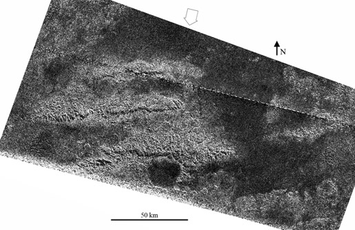
The radar image above, centered in the mountainous region "Xanadu" was captured by the radar instrument of the Cassini probe on May 12, 2008. The dark, parallel lines are believed to be related to tectonics, a phenomenon associated with subsurface instability. Image credit: NASA/JPL
The dark lines or ridges correspond to cliffs, scarps or faults of mountain chains. They are oriented west-to-east and are spaced roughly 50 kilometers (30 miles) apart. The dark lines are dark due to shadowing from the radar illumination and the cliffs are expected to be a few hundred meters (several hundred feet) high, based on preliminary estimates of slopes.
The cliffs have likely been engendered by tectonic forces acting in a north to south direction at Titan's equatorial area. That's a phenomenon suggesting underground layers which are relatively unstable. And to a certain extent, it is not consistent with the idea of a relatively homogeneous mixture from the surface to the interior of the moon. Similar ridges are also observed at a similar latitude, just west of Shangri-La, about 90 degrees to the west which suggests that this kind of tectonics is widespread all over the globe.
Several locations on Titan are thought to host a cryovolcanic activity. One of the candidates for cryovolcanism is Hotei Regio with the bright rims of Hotei Arcus. Brightness changes, observed, imply the possibility of eruptions of NH3 and water and deposition and removal of NH3 frost over a water ice substrate. The decomposition of NH3 would account for the high concentrations of nitrogen in Titan's atmosphere.
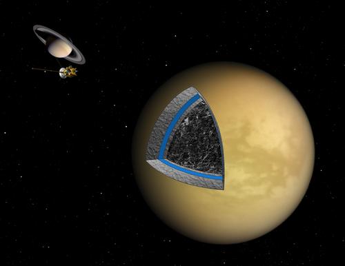
The artistic image above shows the assumed internal structure of Saturn's largest moon. The sphere includes, notably, an upper layer of ice, a thin subsurface ocean and deeper, a mixture of ice and rock. Thus, the moon has not completely differentiated into separate layers of materials. Image Credit: NASA/JPL
- To get more information on that news, go to: http://saturn.jpl.nasa.gov/news/newsreleases/newsrelease20100311, http://saturn.jpl.nasa.gov/photos/imagedetails/index.cfm?imageId=3082, http://cat.inist.fr/?aModele=afficheN&cpsidt=21789314, http://cat.inist.fr/?aModele=afficheN&cpsidt=20454052 or http://www.planetary.org/blog/article/00001775.
March 8, 2010: A "Karst Topography" in the Complex Region of Sikun Labyrinthus?
Sikun Labyrinthus, an intriguing region of Titan, located at about 78 degrees south latitude, 29 degrees west longitude, not very far away from the optically-dark region Mezzoramia, appears to have been shaped and carved by flowing liquids. That's what the radar data and a new analysis suggest.
The Synthetic Aperture Radar view of a landscape portion in which Sikun Labyrinthus appears, acquired from the Cassini probe on December 20, 2007 clearly shows the complex topography of Sikun Labyrinthus made of dendritic patterns of ridges and valleys.
An analytical 3D map of Sikun Labyrinthus revealing the action of flowing liquids and erosion has just been released. This map is the outcome of a collaborative work involving Mike Malaska of Chapel Hill, N.C., Bjorn Jonsson, the Cassini radar team member Jani Radebaugh at Brigham Young University in Provo, Utah and Doug Ellison of the space-related website http://www.unmannedspaceflight.com. Mike Malaska is an organic chemist who is a major contributor on the Internet space forum http://www.unmannedspaceflight.com. He provides numerous high-quality reprocessed images of Titan.
The general view of Sikun Labyrinthus is reminiscent of familiar landscape features on Earth such as the White Canyon in Utah, the Darai Hills of Papua New Guinea and the Guangxi Province in China. Some similarities can be found with karst topography on our planet. Karst topography corresponds to a landscape shaped by the action of water dissolving layers of "soluble" bedrocks which are most often carbonate rocks such as limestone or dolomite. The "Gorges du Verdon" in the south of France represent, for instance, canyons taking shape in a karst terrain.
Karl Mitchell, a Cassini radar team associate at NASA's Jet Propulsion Laboratory in Pasadena, California pointed out: "Even though Titan is an alien world with much lower temperatures , we keep learning how many similarities there are to Earth."..."The karst-like landscape suggests there is a lot happening right now under the surface that we can't see."
The study led by Mike Malaska which results in the assumption that the area of Sikun Labyrinthus undergoes similar geological processes to those in the karst terrain on Earth is based on infrared or near-infrared images (ISS), radar data as well as DISR (Descent Imaging and Spectral Radiometer) images from the Huygens lander.
The 3D view is based on the assumption that liquid flows downward. Mike Malaska classified the landscape portions, valleys, ridges or hills in order to determine the potential relief. Regarding the reliability of the data, he argued:"My artistic model seems to fit the current data."..."Of course, Cassini could do another pass and blow the model away. I'm hoping it will be confirmed, though."
Beyond the visual analogies between karstic regions on the Earth and Sikun Labyrinthus on the Orange Moon, it appears fundamental to lay stress on the fact that the materials or the fluids involved in the cryo-environment on Titan are radically different from those involved on the surface of our planet. There is no liquid water on the surface of Titan due to the particularly low temperatures (-179°C, -292°F or 95K) and the external crust of Titan is likely dominated by water ice, frozen carbon dioxide and/or organic molecules.
The radar swath of December 20, 2007 suggests that a large reservoir of liquids, which seems partially filled, fuels a sinuous radar-dark river connected to the complex network of ridges, valleys and smooth terrain of Sikun Labyrinthus.
The pools and rivers on Titan are thought to be mostly made of methane, ethane and dissolved nitrogen. The observed landscape implies that the enigmatic liquid has a strong power to erode the topography. If Sikun Labyrinthus results from the action of flowing liquids, one can easily imagine the possibility of a network of underground caves.
The origin of the liquid, mainly concentrated in the polar regions of Saturn's largest moon is likely related to meteorology rather than cryovolcanic activities. The observation of frequent cloud formations in the south polar region strengthens the hypothesis for methane and ethane rain filling the topographic depressions and engendering lakes and seas.
Vincent Chevrier of the University of Arkansas is going to lead a "research mission" aimed at determining the exact nature of the liquids on Titan as well as their dynamical properties (evaporation, precipitation) and their interactions. A 2-meter high steel cylinder will be used to mimic the deep and opaque atmosphere of Titan and the interactions with the soil.
A surface pressure about 50% higher than on Earth and temperatures below -178°C, -292°F or 95K are needed to reproduce the extreme conditions on the Orange Moon. Hydrocarbon gas will condense into about 1 centimeter deep "mini-pools" at the bottom of the cylinder. By modifying temperatures, scientists will have the opportunity to figure out the dynamical properties of methane or ethane. What is the correlation between temperature variations and evaporation and precipitation?
Vincent Chevrier advanced:"It is highly likely that the lakes are in fact complex mixtures of ethane, methane and nitrogen."..."We will study the behavior of pure compounds first and then shift to mixtures."
Oded Aharonson of the California Institute of Technology argued: "The rates of exchange of hydrocarbons over seasonal and potentially longer climate cycles on Titan is an important goal of current research."
If Sikun Labyrinthus has likely been carved or shaped by flowing liquids related to a meteorological cycle, that may not be the case for Hotei Regio, near Xanadu in the south of the equator where signs of flowing liquids also appear.
It seems that a meteoritic impact has generated Hotei Arcus and a circular area in Hotei Regio. An optically-bright material can be found as well as bright channels along the rims of Hotei Arcus. The channels are likely the outcome of molten material resulting from the impact. But Hotei Regio could also be a caldera or a cryovolcano. In that case, the sinuous channels would ralther be frozen cryolava.
If Hotei Regio is an impact crater and that a subterranean ocean is present, some crustal weaknesses may lead to fractures or upwelling or eruptions of molten material. A recent Synthetic Aperture Radar view unveils a one-kilometer-deep (half-mile-deep) depression in the middle of Hotei Regio where bright volcanic deposits, about 100 to 200 meters (300 to 700 feet) thick seem to cover the surface.
As a result, the comparison of two key regions of Titan, Hotei Regio and Sikun Labyrinthus, suggests that they are radically different in terms of geological processes. Hotei Regio may result from a meteoritic impact whereas Sikun Labyrinthus may result from the action of flowing liquids related to the meteorological cycles of Titan.
However, there is no certainty and Sikun Labyrinthus could well be a rugged landscape generated by the eruptions of molten material from a meteoritic impact. The smooth part of Sikun Labyrinthus would most likely, in that case, account for the impact area.
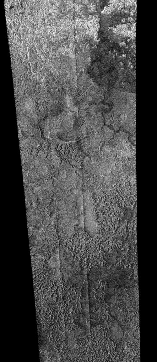
The Synthetic Aperture Radar swath above which was captured on December 20, 2007 from the Cassini spacecraft reveals a radar-dark basin connected to what seems to be a large drainage channel fueling the dendritic, complex and rugged terrain of Sikun Labyrinthus in the lower part of the radar strip. The view is centered near 76.5 degrees south latitude, 32.5 degrees west longitude. The area is close to the region of Mezzoramia. The radar view covers, approximately, an area 620 km long (385 miles) and 270 km wide (170 miles). Image source: NASA/JPL
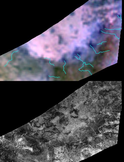
The mosaic above which combines a near-infrared or infrared view in the upper part and a radar view in the lower part unveils the region of Hotei Regio and Hotei Arcus near Xanadu in the southern hemisphere of Titan. Some bright, sinuous channels can be clearly spotted along Hotei Arcus. They correspond to the blue dendritic lines incorporated into the top view. An optically-bright material can be well identified inside Hotei Regio. It may be the outcome of a meteorite. It may also correspond to a caldera or a cryovolcano. The debate upon its geologic nature continues. Image source: NASA/JPL/USGS/UA
- To get more information on that news, go to: http://saturn.jpl.nasa.gov/news/cassinifeatures/feature20100304, http://saturn.jpl.nasa.gov/news/cassiniscienceleague and http://www.astrobio.net/exclusive/3385/studying-titan’s-lakes-on-earth.
January 27, 2010: A New Radar Image of Titan Reveals Topographic Wrinkles which May Be Related to Tectonic Forces
Saturn's largest moon, Titan is known to be a "paradise" for geologists because its surface appears particularly complex, active and varied. A small amount of impact craters have been identified, yet. Of course, the atmosphere acts as a shield against the extraterrestrial objects such as comets or asteroids. However, the internal forces of the Orange Moon may also play a key role in maintaining the youth of Titan's surface. In other words, cryovolcanoes or geysers may help erase the geological scars generated by meteorites. Don't forget that weathering or erosion resulting from rainfall and winds are likely to have a strong impact on the appearance of Titan's surface, as well.
A new radar image obtained on December 28, 2009 by the Synthetic Aperture Radar or the Radar Mapper from the Cassini spacecraft unveils topographic patterns which represent new clues that tectonic forces are still dynamic on the Hazy Moon. One can notice, notably, in the radar portion, topographic wrinkles, hills and grooves. The network of channels, wrinkles and hills or mountains forms, roughly, a radial pattern or an oval, flattened, approximately, from north to south.
Image source: NASA/JPL
This irregular area is located in the lower-right part of the radar portion. The global view lies at about 41 degrees north latitude and 213 degrees west longitude. The radar view measures 250 kilometers (160 miles) vertically and 285 kilometers (180 miles) horizontally. North is in the left part of the image and the illumination comes from the upper part with an incidence angle varying from 11 to 25 degrees. The area can be found, approximately, at a similar latitude to Adiri and well above this region in the northern hemisphere. The region in which the grooves are located is known as Belet. The grooved mounds are approximately 80 kilometers (50 miles) wide and grosso modo 60 meters (200 feet) high.
In the north part of the view or in the left part of the radar image, one can notice bright, linear streaks which are well aligned or parallel following a similar direction, roughly from west to east or east to west, a little southwards. Those geological formations are reminiscent of Seif dunes which are widespread in the optically-dark tropical region of the moon. The bright scratches may take shape under the influence of prevailing winds. The bright material is likely less compact, less dense or less stable than the radar-dark material which appears quite uniform in this view.
In the upper part of the radar image, one can observe that in the bright patch dominated by parallel topographic lines, dark branching networks can be found as well. Is it related to lava flows resulting from cryovolcanoes? Is it the outcome of an ancient meteoritic impact? Is it the result of a tectonic activity? Or is it simply a network of drainage channels or rivers resulting from rainfalls?
The dark branching networks which show irregular patterns are also clearly visible in the lower-right part of the view where hills, mountains or grooves can be found. Those landscape features show some similarities with spidery features known as coronae on Venus. A corona is a circular to elliptical topographic pattern believed to result from the flow of heat in the interior of the planet or the moon.
Steve Wall of NASA's Jet Propulsion Laboratory, Pasadena, California , a Cassini scientist on the radar team pointed out: "This star-shaped pattern of the hills indicates something significant happening in the middle of the star."..."It might be caused by tectonic forces, such as the forces that pull the crust of a planet apart, or rainfall that leads to erosion, or an ice intrusion like a dike."
Volcanism, cryovolcanism or geysers have been observed on Saturn's moon Enceladus, on Jupiters's moon Io and on Neptune's moon Triton. Due to tidal forces exerted by Saturn and the other moons, it's likely that Titan still shows a strong internal activity as well as active surface processes. The topographic wrinkles in that area represent new "candidates" for cryovolcanism or tectonic activity on the Orange moon. Several other areas of the globe are believed to be cryovolcanic features: one can mention, notably, the bright Hotei Arcus.
It is often difficult to distinguish topographic features between cryovolcanic calderas which are circular, volcanic features and impact craters which are generally circular, as well. Among the candidates for craters or cryovolcanoes, one can mention Sinlap, Omacatl Macula, Santorini Facula, Kerguelen Facula, Shikoku Facula, Guabonito and Nath.
- To get further information on that news, go to: http://saturn.jpl.nasa.gov/news/cassinifeatures/feature20100125
Titan
News 2009
Titan News 2008
Titan
News 2007
Titan
News 2006
Titan News
2004, 2005