Interpreting Titan Radar Images
 |
 |
 |
 |
 |
 |
 |
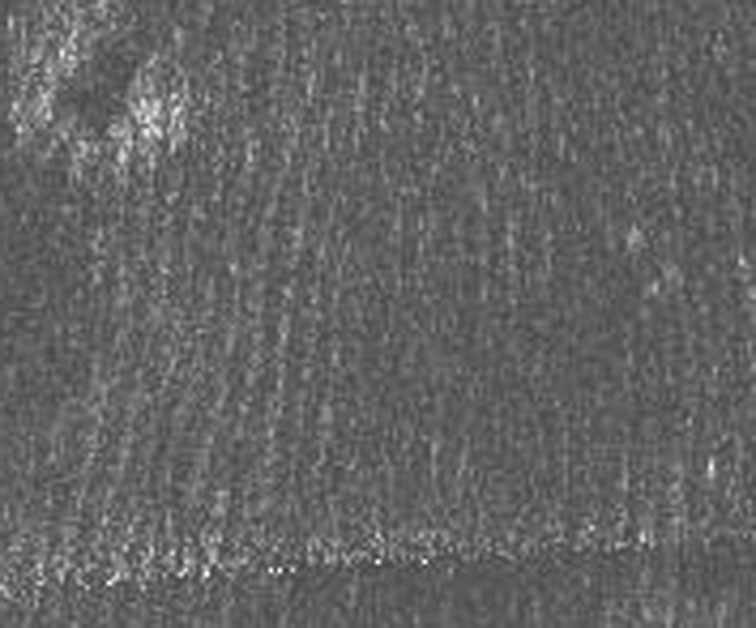
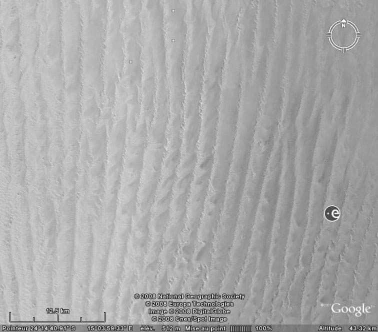
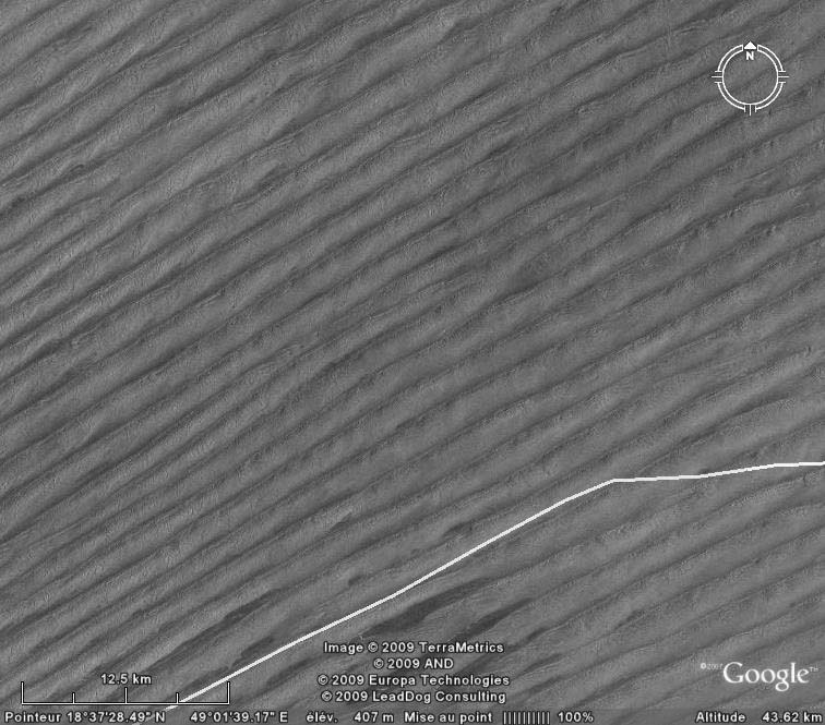
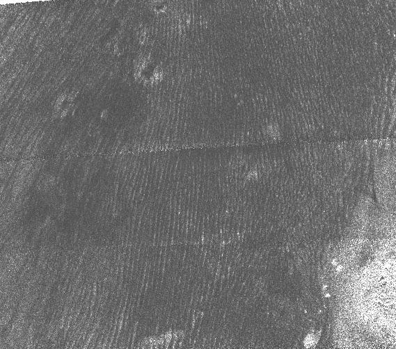
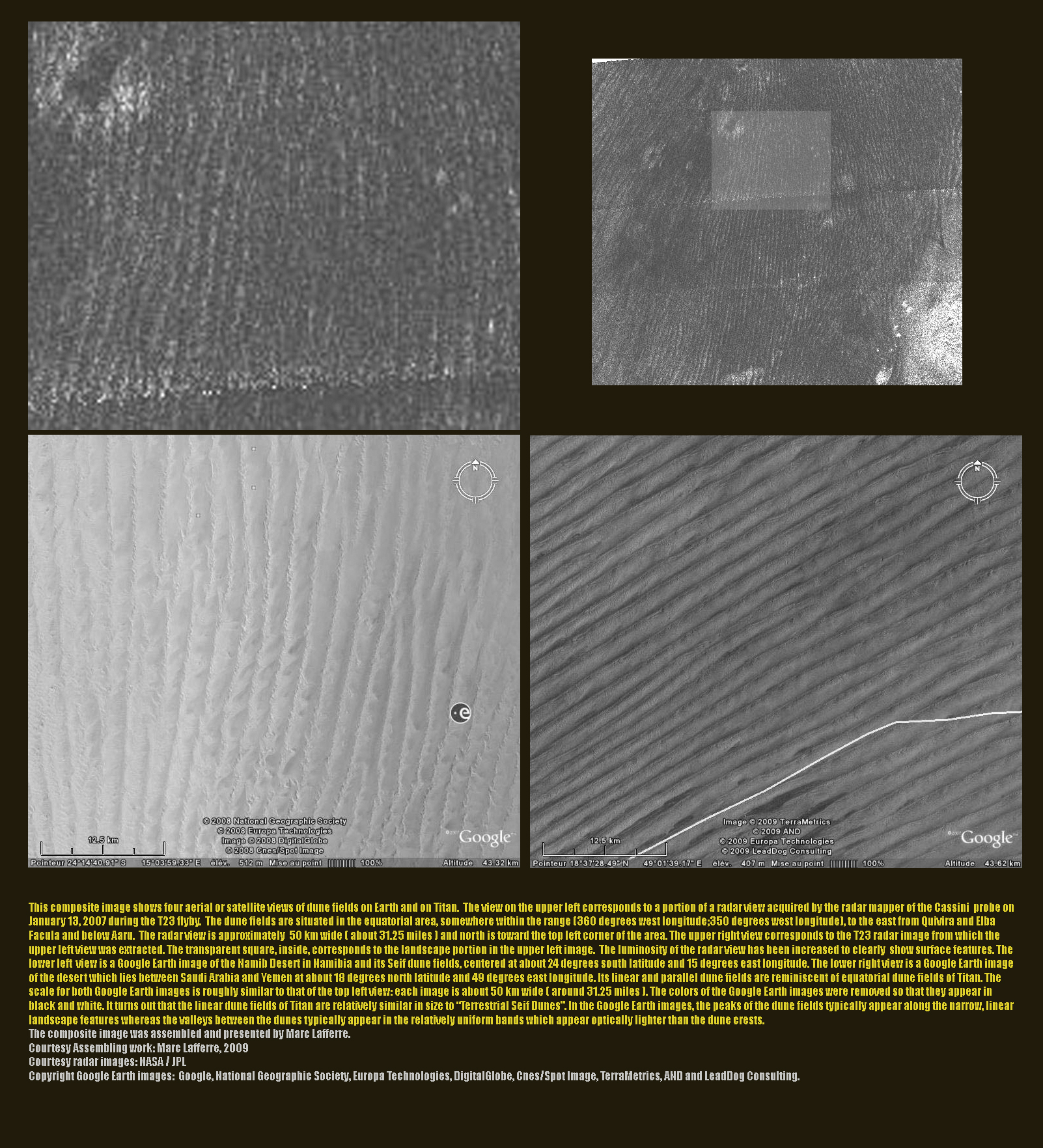
This set of images of Titan's
"Cat Scratches" and particular dune fields on Earth ( Seif Dunes,
linear and parallel dunes ) aims at analysing and comparing Titan's
equatorial "Sand Seas" and linear and parallel dune fields
on our planet. The composition of the assumed dunes of Titan is still
unknown: however, the
way the dunes are shaped by prevailing winds is likely to bring
new clues on the nature of those exotic dunes. The
Titanian dunes are thought to primarily consist of organics in the
form of sand-sized particles. The composite image was assembled and presented by Marc Lafferre. |
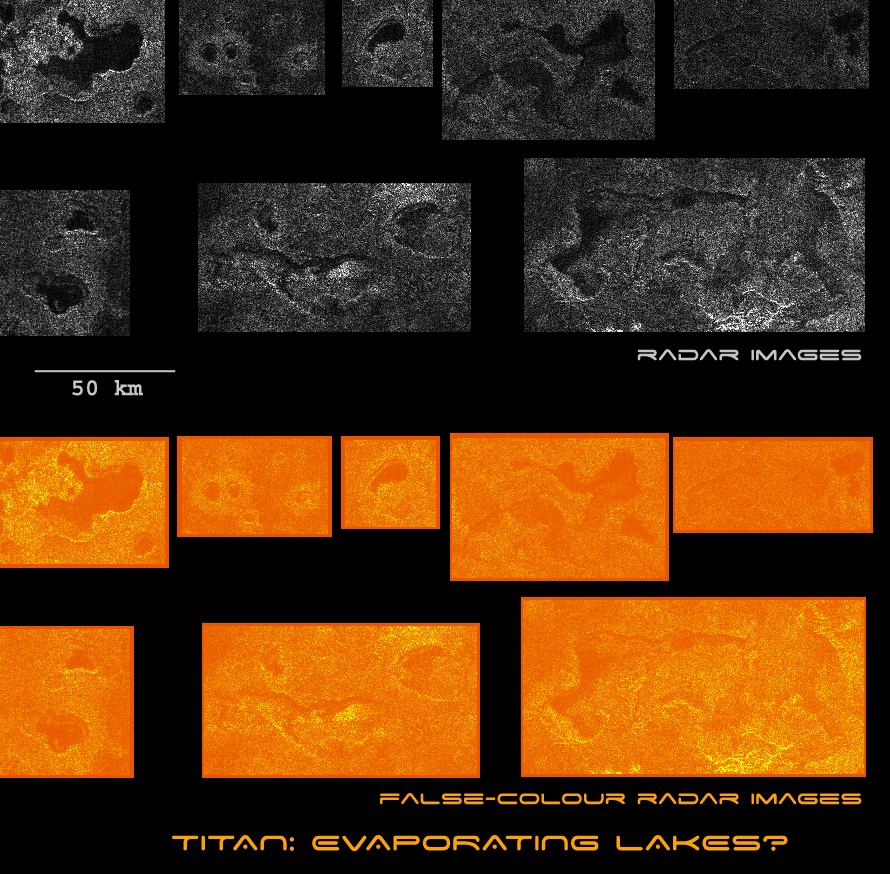 |
Source: NASA, JPL, www.titanexploration.com This set of radar images shows some landscape features of a radar strip obtained by the the Cassini's radar in synthetic aperture mode during the flyby of July 22, 2006. The swath begins at 20 degrees north by 142 degrees west and ends at 13 degrees north by 347 degrees west. The dark lakes begin to appear at about 70 degrees north. The selected lakes above seem to be evaporating. For instance, the landscape feature on the lower right appears to be a dried-up lake, almost empty. The western part of the lake remains apparently wet due to its dark color. The rims are clearly visible with the erosion engendered by the liquid. Some radar images reveal lakes which are not as filled as they used to be due to the wide depressions surrounding them. The lakes on the lower left image are likely in that case. The north pole seems to be the wettest region with very dark lakes on the radar images. As we go away from the pole, the lakes tend to be drier with lakes sometimes completely evaporated. PS: This mosaic is proposed by the team of www.titanexploration.com on the basis of radar images captured by the Cassini spacecraft. The work was led independently by the team. As a result, NASA and JPL are not responsible for the accuracy of the data presented here. |
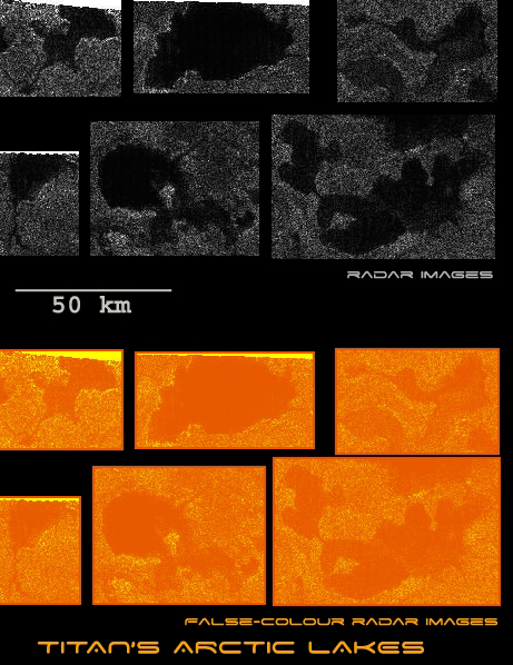 |
Source: NASA, JPL, www.titanexploration.com This mosaic of radar images corresponds to a selection of lakes present in Titan's northern latitudes. They are part of a radar strip acquired by the Cassini's radar instrument in synthetic aperture mode during the flyby of July 22, 2006. The swath begins at 20 degrees north by 142 degrees west and ends at 13 degrees north by 347 degrees west. The dark lakes have the particularity of being located in the north pole region. They begin to appear at about 70 degrees north. The selected lakes, here, have drainage channels. One can notice that two lakes are interconnected on the lower right of the mosaic. One can also observe two islands or peninsulas. The detection of what appears to be ethane cloud formations around the arctic region suggests that the nature of the liquid might be ethane. But the lakes might also be composed of methane or nitrogen. Some dark patches in the north polar region present a circular shape surrounded by a bright material. Are they calderas? Is it linked to cryovolcanism or a meteoritic impact which would have uncovered a subsurface ocean? PS: This mosaic was produced independently by the team of www.titanexploration.com on the basis of radar images captured by the Cassini spacecraft. As a result, NASA and JPL are not responsable for the accuracy of the data presented here. |
 |
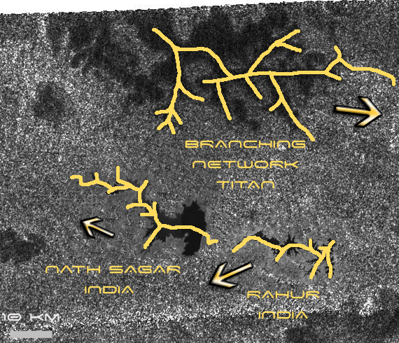
Source: JPL, NASA, www.titanexploration.com In this radar image of Titan captured during the flyby of October 9, 2006 and centered near 80 degrees north latitude and 357 degrees west longitude, two terrestrial lakes have been added and put at the scale of the image. The radar image measures about 310 kilometers by 100 kilometers ( 190 miles by 62 miles ). In this "artificial construction", we are going to compare and analyse terrestrial lakes and what is supposed to be lakes on Titan. The goal is obviously to determine whether the lake-like features of Titan are truly carved by a liquid. The central question, here, is related to the dark branching network, top left of this radar image. It is around 60 km or 37 miles long ( from left to right ). The earthly lakes we've added are located middle left on this image ( two very dark patches below the branching network ). The lake on the left is about 35 km long ( 22 miles ) and the terrestrial lake on the right is around 20 km long or 12 miles ( from left to right ). Both lakes were originaly taken on Google Earth: the lake on the left is a man-made lake. This lake, called Nath Sagar, is located in India, 4 km north of Paithan town ( not very far from Aurangabad ). It is the result of an earthen dam, the Jayak Wadi Dam, on the river Godavari ( Eastern edge of the lake). The lake on the right is the lake of Rahur and it is also an artificial lake with a dam on its eastern rim which enabled the formation of this large reservoir. A specialist of geography or topography analysing this cutting will probably note a potential anomaly in terms of realism. Both terrestrial lakes are fed by a river coming from the right which explains their shape with subdivided channels pushing westward. On the other hand, as Marc Lafferre points out, if we postulate that the Titan branching network ( top left of the image ) is a lake, we can say that the direction of the stream is likely eastward because wide dark channels are subdivided in an eastward sense which is the sense of dominating winds on Titan. But can we say that the liquid is still present ? Another landscape characteristic which tends to demonstrate the presence of lakes and rivers in this area is a long and relatively narrow dark connected channel, ending on the east rim of the dark branching network. It is likely a drainage channel. PS: This cutting is derived from a radar image of Titan, released by NASA and JPL. Two terrestrial lakes taken on Google Earth by the team of www.titanexploration.com were added. As a result, NASA has nothing to do with that cutting. The analysis was led independently by the team of www.titanexploration.com. |
 |
 |
Source: JPL, NASA, www.titanexploration.com In this region of a radar image acquired during the Titan flyby of October 9, 2006, we have added two terrestrial lakes, the Nath Sagar lake and the lake of Rahur, both located in India. The terrestrial lakes are artificial: dams on the east coast of the rivers conducting to the lakes have been constructed and a large reservoir formed. On top of the radar image, we observe a branching network with subdivided channels. The earthly lakes also show subdivided channels. The cut on the left image allows us to determine the sense of the stream, indicated by an arrow. The sense of the stream leading to the Indian Lakes is westward whereas the sense of the assumed fluid in the Titan branching network is likely eastward due to the way the channels are subdivided and orientated. Let's notice that the eastward orientation is also the orientation of dominant winds on Titan. Another clue which tends to show that the sense of the branching network is eastward is the presence of this long and narrow dark channel ( at least 10 km long ), likely a drainage channel, ending this dark landscape feature on the east. PS: This editing is based on the original radar image taken by the radar instrument onboard the Cassini spacecraft. The terrestrial lakes, taken on Google Earth, were added on this map at the correct scale by Marc Lafferre. The illustration is the work of our team. As a result, NASA, JPL and the Cassini Imaging Team have nothing to do with that work. The analysis was led independently by the team of www.titanexploration.com. |
|
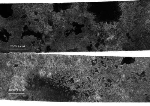 |
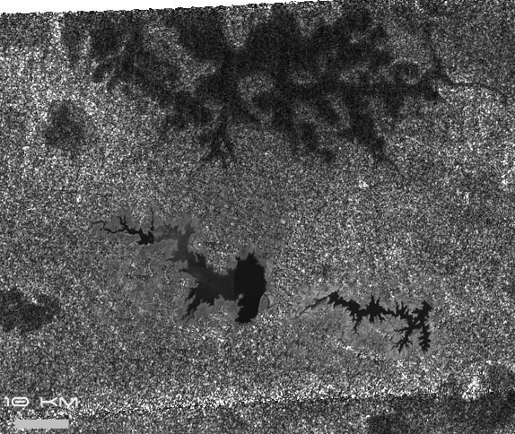
Source: JPL, NASA These two radar images of Titan were taken at high latitudes on July 21, 2006. Planetologists examined these radar images with a great enthusiasm: it is undeniably the most significant clue that Titan harbours methane or ethane lakes. Until this flyby, no radar image had shown patches as dark as those observed here. It was assumed that the north polar region was filled with lakes or seas since the north pole is currently in the winter season and previous infrared images had revealed that the north pole might be composed of a multitude of seas or lakes. The flyby of December 26, 2005 had allowed the Cassini spacecraft to identify striking characteristics in the north pole: it appears very bright at infrared wavelengths as in the south pole: Does it imply cloud formations? The upper part of the image was acquired at 80 degrees north and centered at 92 degrees west. It is around 420 km long ( 263 miles ) and 150 km large ( 94 miles ). The lower part of the image was captured at 78 degrees north and centered at 18 degrees west. It is around 475 km long ( 297 miles ) and 150 km large ( 94 miles ). The dark areas indicate a low reflectivity or albedo similar to that of seas on Earth. The observation of clouds and seas on Titan is a strong evidence that Titan is governed by a methane cycle. As Jonathan Lunine points out, Titan is covered with a methanosphere. It is a great source of comparison with the hydrosphere of planet Earth. As Titan's northern latitudes are colder, it seems that the temperatures, here, play a key role in developing and maintaining hydrocarbon seas. The largest visible dark patch is about 90 km across ( 56 miles ). Are those dark patches related to meteorites ? this hypothesis is very unlikely because the dark areas have irregular shapes with clear rims or boundaries. Moreover, the dark patch on the upper right of the lower image is connected to a dark channel, at least 5 km long ( 3 miles ). It's likely a drainage channel filled with methane or ethane. PS: The scale appearing on the radar images was added by the team of www.titanexploration.com. |
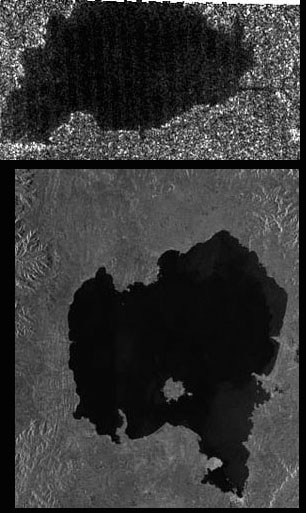 |
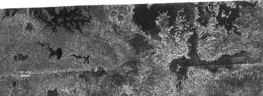
Image source: NASA, JPL These two images represent radar images taken on Titan and on Earth. The upper part image corresponds to one of the dark patches spotted at 78 degrees north latitude of Titan , in the winter hemisphere. It's likely a lake of methane or ethane. Several clues tend to show that this is a liquid area. The boundaries with the bright area are clear like terrestrial coasts. The patch appears uniformly dark in radar images which means that it is very absorbing. A dark channel on the right side of the assumed lake can be clearly identified. Its visible part is at least 5 km long ( 3 miles ). No doubt that this is a drainage channel. The lake itself is about 47 km long ( 29 miles ) and 25 km wide ( 16 miles ). The second radar image represents a terrestrial landscape. It reveals lake Tana in Ethiopia. Its size is roughly the same as the Titan lake above ( around 50 km across ). Thus, the comparison is interesting. No clear drainage channels appear in this image. By contrast, the lake above shows multiple drainage channels. PS: This set of images is proposed by the team of www.titanexploration.com on the basis of NASA and JPL images. The original color image of lake "Tana", Ethiopia was transformed into a black and white image to make the comparison with Titan's radar images more relevant. |